
10:00am update:
A Hurricane Watch has been issued for the east coast of Florida from
north of Deerfield Beach to the Volusia/Brevard County Line.

A Storm Surge Watch has also been issued from north of Deerfield
Beach to the Volusia/Brevard County Line.
9AM UPDATE:
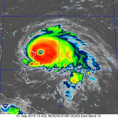
BREAKING NEWS….DORIAN WINDS NOW 175…
The eyewall of #Dorian is reaching the Abaco Islands. Residents there should take immediate shelter. MaX winds have increased to near 175 mph, gusts over 200 mph. Extreme winds and storm surge will continue for several hours. https://nhc.noaa.gov/text/refresh/
7AM HURRICANE DORIAN UPDATE:
Welcome to September! Some of you had some nice downpours yesterday. And, some of you will encounter some nice downpours today. They will be random. But, there will be a generous supply roaming around. After today, the rain chances will go down. Part of that is an indirect effect from Hurricane Dorian. For all of you who have family and friends from Florida to the Carolinas….I don’t like the new model trend I’ve seen overnight, which edges Dorian’s track back closer to the coast, again. Much more on Dorian below.
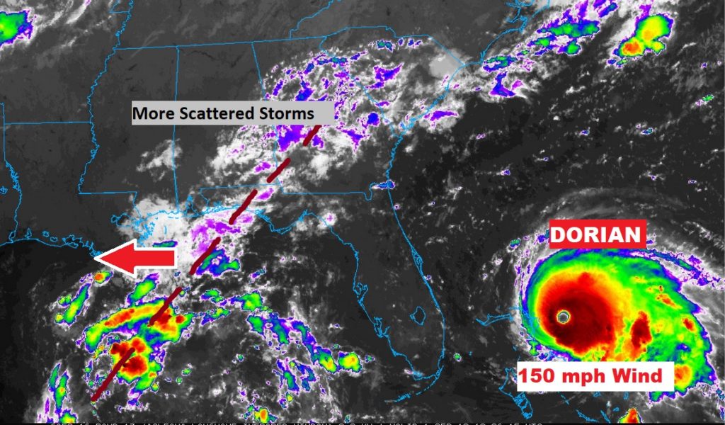
TODAY: We have, for lack of a better description, a westward moving tropical wave affecting us today. Again today, like yesterday, there will be a generous supply of those random storms. Hot, and extremely humid. High today 93. Low tonight 72. This image below gives you an idea of this “axis of moisture” from Alabama into the central Gulf. Tomorrow it will be past us…and the rain chances will go down.
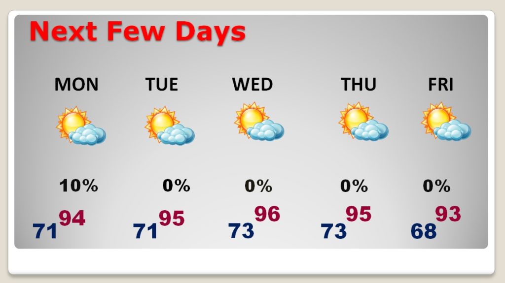
NEXT FEW DAYS: After today, our rain chances trend downward. On Labor Day, I have our chances under 20%, and I have no rain chance indicated Tuesday through Friday. It’s a HOT this week. High in the mid 90’s
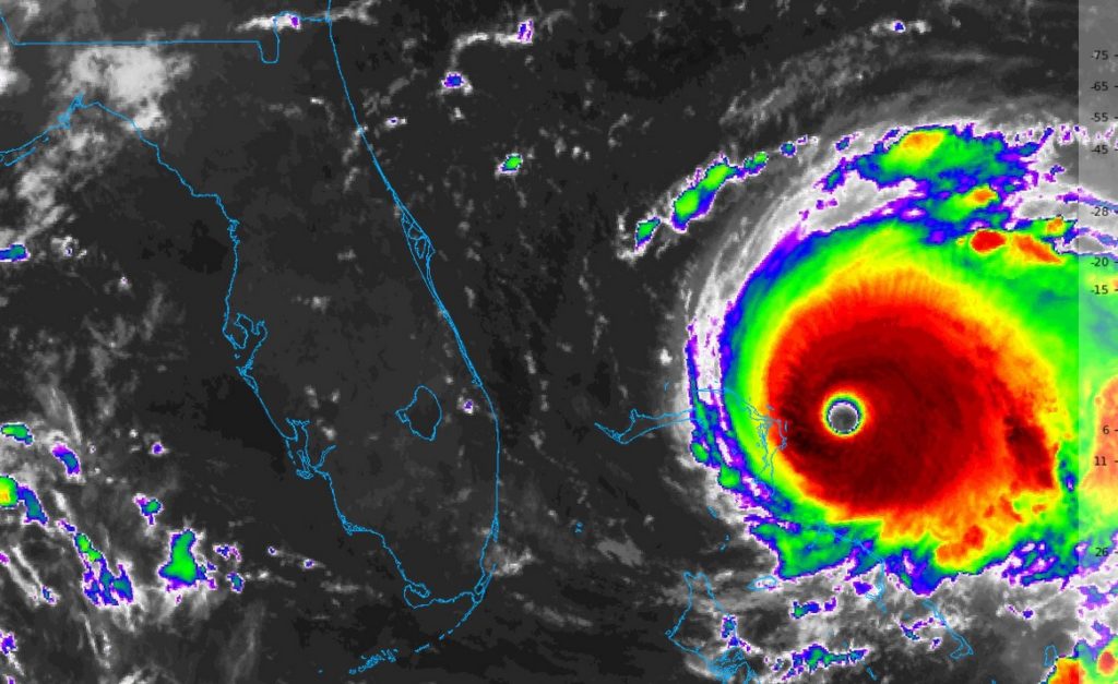
HURRICANE DORIAN UPDATE: First, let me start out by saying, our thoughts and prayers are with the people of the beautiful Bahamas. Today and Monday, Extremely Dangerous, nearly Cat 5 Dorian will tear through the northwest Bahamas. Please keep them in your thoughts.
There has been a disturbing trend overnight. A couple of the key models have edged the Dorian track back westward closer to the eastern Florida coastline.
Here’s a “Loop” of the Euro forecast model, which shows a close call for Florida, Georgia and the Carolinas
So, the National Hurricane Center has nudged the Dorian Cone a little westward again. Dorian is an Extremely Dangerous Cat 4 Hurricane with 150 mph winds moving west at 8. The pressure is a jaw-dropping 934 mbs. This storm is destined for the history books.
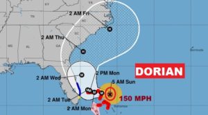
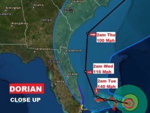
Cone Close up with details.
NHC has this key message for Florida:
“A tropical storm warning is now in effect for a portion of theFlorida east coast. Since Dorian is forecast to slow down and turnnorthward as it approaches the coast, life-threatening storm surgeand dangerous hurricane-force winds are still possible alongportions of the Florida east coast by the middle part of this week.Residents should have their hurricane plan in place, know if theyare in a hurricane evacuation zone, and listen to advice given bylocal emergency officials.”DORIAN on it’s current track, is NOT expected to have a direct affect on Alabama’s weather.
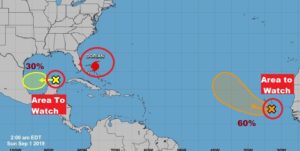
ELSEWHERE IN THE TROPICS: There continues to be two “Areas to Watch” on the map. One is way off Africa, the other one is a system in the Gulf moving westward which NHC now says has a 30% chance of development.
—
I will have another Blog Update first thing in the morning. Have a nice Labor Day weekend! I’ll keep you up to date.
–Rich