
I am not going to sugar-coat this. I’m concerned. There will be a significant Severe Weather Event across the Deep South today. Alabama is the bulls-eye. Multiple hazards are likely including widespread damaging winds, large hail, and tornadoes are probable, including a few strong long-tracked tornadoes.
The threat level is particularly high. Level 4 out of 5 is significant. Coming on the heels on the historic Easter Sunday outbreak, there’s a danger some folks may let their guard down. Let me be clear. My concern level today is as least as high as it was last Sunday.
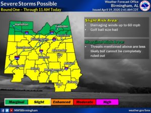
MORNING STORMS: As I type this, a morning round of strong/severe storms is already in progress. As a warm front continues moving northward, some thunderstorms will produce damaging winds and hail larger than golfball size. This round one of storms should be over by lets say mid to late morning. Then, there will be a lull for a few hours, before the much more dangerous round will begin to ramp up.
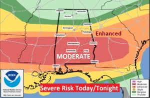
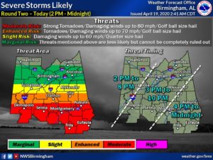
SEVERE WEATHER RISK THIS AFTERNOON/TONIGHT: On a FIVE scale. The Prediction Center has settled on a Level 4 MODERATE risk in a strip across the Deep South. They toyed with the idea of a notch higher. No matter, the parameters for Severe Storms with wide-spread Damaging wind gusts to 70+, large hail. Tornadoes are probable in Alabama today. A few strong long-tracked tornadoes are certainly a possibility. The timeline for the main event begins mid-afternoon in the west and spreads across the area by late afternoon, through this evening and tonight, ending for many of us in the wee hours of Monday morning.
During the afternoon and much of the evening time frame, the treat will involve individual thunderstorms which develop in a very ripe, warm, moist environment. These storms will reach severe limits and will start to rotate, producing tornadoes. Later tonight, the focus will shift to a broken line of strong thunderstorms which will produce widespread damaging wind gusts, large hail and embedded tornadoes. Flooding is also possible. See below. Flash Flood Watch. ROUGHLY, I would put the time line from about 2PM West to about 2AM east.
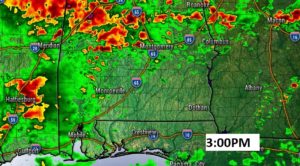
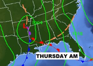
FUTURE RADAR: Couple of simulated radar models ideas I want to share. Clusters of strong thunderstorms will move out of eastern Mississippi into Alabama by mid afternoon. Some will produce tornadoes.
The “cellular” tornado threat will continue across the area well through the evening, including the threat of some strong, long-tracked tornadoes.
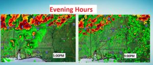
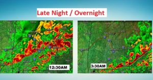
Late night and overnight, the threat evolves into a line of strong storms (QLCS) with the threat of widespread damaging wind gusts, embedded tornadoes, large hail and flash flooding possible. Most of the storms will probably exit the eastern counties near or about 3 or 4AM.
This timing graphic from NWS Birmingham may be helpful.
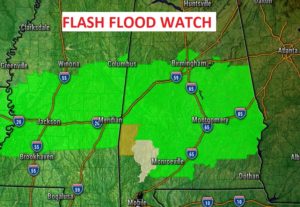
FLASH FLOOD WATCH: The threat of localized flash flooding with this system will be significant across central Alabama. A Flash Flood Watch has been issued for central and a good part of Alabama.
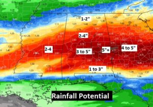
A band of locally heavy rainfall amounts will line up somewhere across central Alabama. Some of the heaviest rainfall totals will be generally along and north of the I-85 corridor. Amounts over 4” are certainly possible, and locally up to 6” in spots.
TAKE TODAY’S SEVERE THREAT SERIOUSLY:
There is a danger that some folks might let their guard down with THIS severe weather event. We need to treat this Level 4 MODERATE risk with great respect. Tornadoes are probable. Loss of life is possible. Damaging winds could be widespread with this system. Do not let your guard down. Be ready to take action and get your family into your safe place.
Wear shoes. If you have helmets…wear them during a warning. You need at least two reliable ways to get a warning. Our weather app could be one. A Weather Radio is a very reliable way to get a warning. It will wake you up when a warning is issued. Do not rely on hearing a weather siren. They are only designed to be heard by those who are outside, and, they sometimes malfunction. Stay in your safe place during a warning. You can watch our LIVE stream on our weather app. Download the App by going to the app store and search Rich Thomas Weather.
WATCH OUR LIVE STREAM: I’m happy to say, our LIVE stream will be much easier locate now. On the Rich Thomas Weather App. Click on the You Tube Tab..and you’ll see Rich Thomas Weather Live stream. You can easily go to this link: richthomasweathernetwork/live on any device or computer. On smart TV’s and ROKU, you can see our Live Stream on You Tube at Rich Thomas Weather. I’ll also be interrupting across the 8 station Bluewater family of radio stations. I’ll also be assisting our friends at the Alabama News Network (CBS 8 and ABC 32). Shane and Ryan and Ben will cut away to me at times.
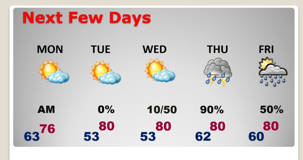
NEXT FEW DAYS: Monday will be a much calmer day. Partly sunny by afternoon. High upper 70’s Near 80 Tuesday and Wednesday. There will be another significant storm system Wednesday night into Thursday with the threat of more Severe Weather and tornadoes. BUT, I’m not gong to spend time talking about that on this blog update. We’ll worry about that later.
—
I’ll be with you today and tonight, on social media, on our weather app, on our live stream, on the radio and on TV.
We’ll get through this. Stay Weather Aware.
–Rich