
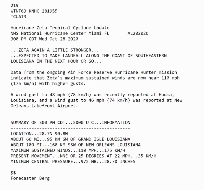
4:00PM:
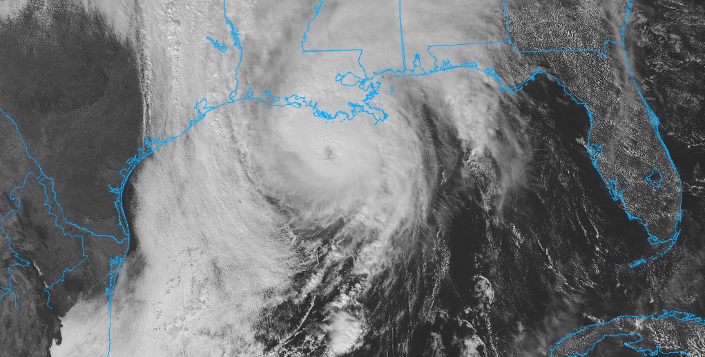
…ZETA MAKING LANDFALL IN SOUTHEASTERN LOUISIANA…With 110 mph winds, now 65 miles SSW of New Orleans, moving NNE at 25.
3:00PM UPDATE:
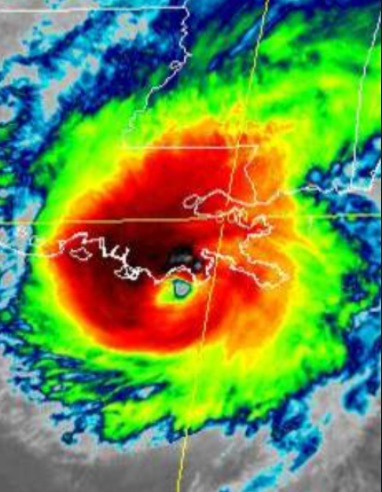
ZETA is now nearly a Cat 3 Hurricane. Winds are up to 110. Cat 3 Begins at 111 mph. This is pretty serious. Should make landfall in the next hour or so.
2:00PM: We’re now getting hourly updates on Zeta. Winds have now increased to 105 mph. (Sally’s strength at landfall) Eyewall expected to reach the Louisiana coastline in an hour or two.
1:00PM UPDATE:
Zeta is now a Category 2 hurricane with 100 mph winds, 255 miles SSW of New Orleans, moving NNE at 20 mph. Expected yo make landfall as a Cat 2 hurricane later this afternoon.
—
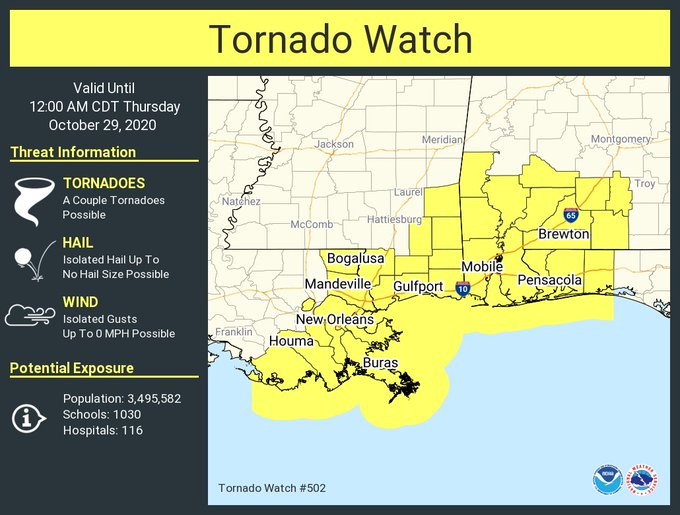
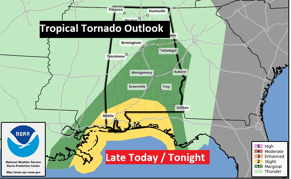
TORNADO WATCH for much of south and SW Alabama until Midnight tonight. Tropical tornadoes will be quick, brief and fast moving. The watch is as far north as Crenshaw and Wilcox counties.
7AM UPDATE:
At 7 AM the winds in Zeta are up to 90 mph now. We only have to get to 96 mph to reach category 2 hurricane. We may have a cat. 2 hurricane making landfall on the Louisiana coast later today. By the way, Cat 3 intensity begins around 110 mph.
EARLY MORNING UPDATE:
Good morning! We have much to discuss. First, on this blog update, a brief video intro and update of my situation, an a explanation for shifting back to a BLOG Update.
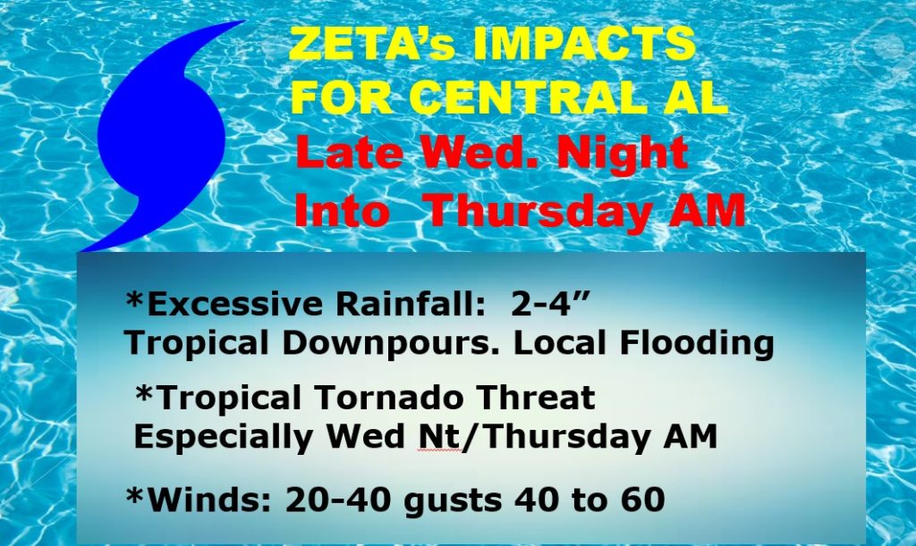
Zeta will have a he impact on weather, beginning tonight, and particularly late tonight into early Thursday morning. As you will see on this Blog update, there are multiple hazards expected from Zeta. The biggest concern will be the strong wind gusts, enough to bring down trees and powerlines, causing possible power outages across a multi-county area overnight. Some roads will be blocked by fallen trees. There will be some Heavy Downpours, and a can’t rule out a few tropical tornadoes, beginning late today and into tonight, as Zeta makes landfall along the North Central Gulf Coast.
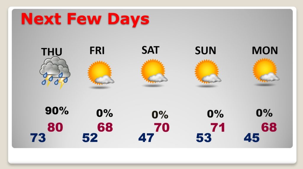
The system will be moving very, very quickly. It will exit the state later in the morning tomorrow, leading to vast improvements tomorrow afternoon, followed by a Nice Fall Halloween Weekend.
ZETA UPDATE THIS MORNING:
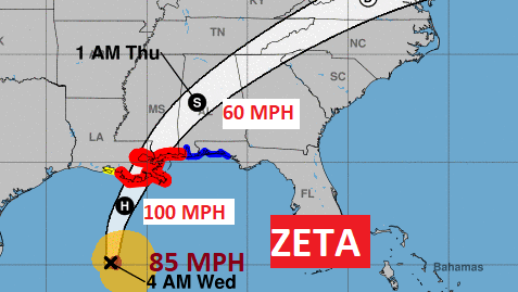
Zeta is an 85 mph Cat 1 Hurricane, located 335 SSW of New Orleans, moving NNW at 17 mph. It could still strengthen more. It could become a Cat 2 hurricane. Expected to make landfall as a Hurricane perhaps late this afternoon on the Louisiana coast.
Zeta will bed the 11th landfilling storm is the United States this season.
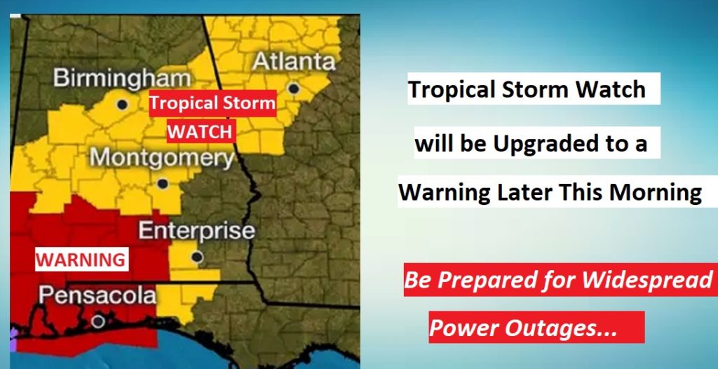
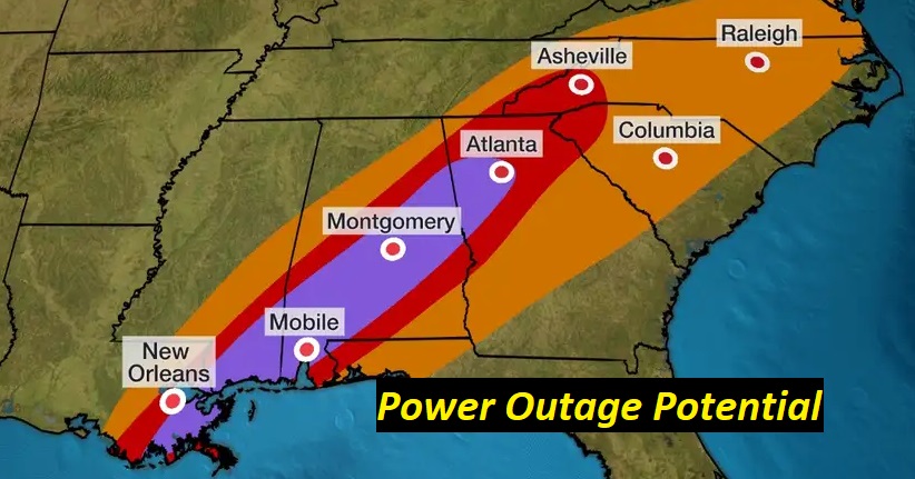
ZETA’S EXPECTED IMPACTS: I can’t emphasize enough, I expect power failures could be widespread through the heart of Alabama, as trees and powerlines come down overnight. Roads will be blocked. The Thursday morning commute could be rather difficult, indeed. Be ready for the loss of power.
In addition, locally heavy rain could easily total 2-4” in only a few hours, causing local flooding. And, the tropical tornado threat will continue along and to the east of Zeta’s exact track.
RIGHT NOW, Most of central Alabama is under a Tropical Storm WATCH, but I expect that will be upgraded to a Tropical Warning later this morning.
The tropical tornado threat will be highest across south and coastal Alabama, beginning this afternoon and tonight. A smaller Marginal Risk exists as far north a Birmingham and Anniston.
The wind field will be intense. Look at one model idea of what the maximum wind gusts could be around 2AM. The early morning hours could be pretty rough. Today, secure lawn and patio furniture, which could become deadly projectiles in the storm.
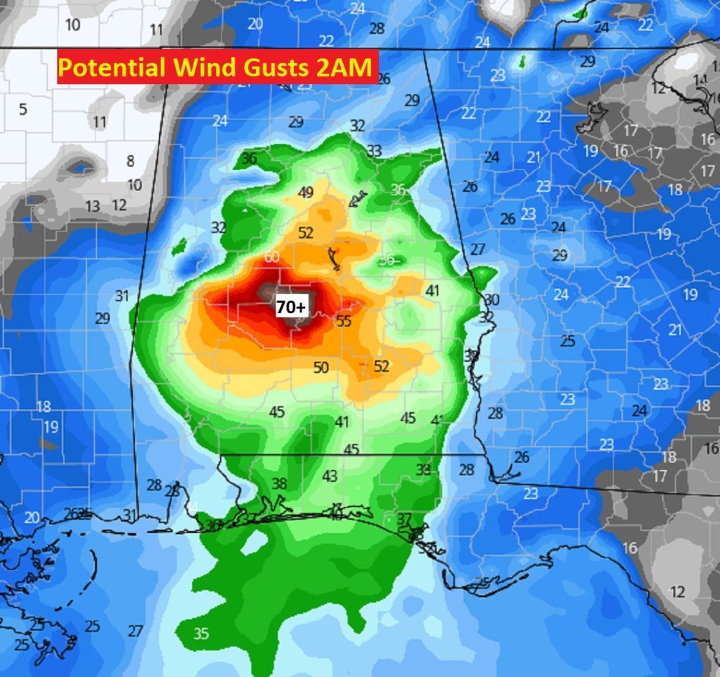
The intense winds will cause widespread power outages through the heart of Alabama. Be ready. Have flashlights ready, charge up your cell phones.
So, here’s a review of the expected impacts and hazards from Zeta here in central Alabama. Expect Tropical Storm conditions. I have listed wind gusts high as 60, but it could be a little higher than that.
NEXT FEW DAYS: After Zeta, things get MUCH better. Great Fall weather…with cool comfortable days and chilly nights. Looks like a Great Halloween weekend. There is a Full Blue Moon on Halloween. Don’t forget the time change late Saturday night / Sunday morning at 2AM.
- –
I’ll will keep you up to date during the day and of course tonight, as best I can, on your Weather Blog, on social media and on the radio. Stay Weather Aware and be ready for quite a slap in the face from Zeta.
–Rich