
Good Morning! The HEAT is still a big issue to talk about, but the tropics are about to become a big deal for all of us here in the Gulf South. The Heat Index yesterday reached a ridiculous 114. The actual high of 101 was almost a record. Today we’ll be in the same boar and the same territory. The Heat Advisory remains in effect. There WILL be storms on the radar today like yesterday. But, your chances of encountering one will be small. Ain chances get better tomorrow, and much better stating Monday. Temperatures come down next week, too, as the Upper High breaks down. But, all eyes are on Invest 93-L in the west Caribbean. This system will certainly become at least a Tropical Storm as it evolves northward in the eastern Gulf. The next available name is IDAILIA. But where will it come ashore an when. Below I’ll give you the possible scenarios. Here’s my brief forecast discussion.
CLIMATE DATA: Friday was perhaps the hottest day of the summer so far. The Actual high was 1 degree shy of the record. High was 101. Morning low 74. Heat index reached a ridiculous 114. Normal 93/71. No rain.
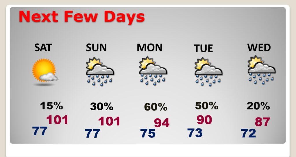
TODAY (Saturday): Heat Advisory in effect. Sunshine. Very Hot. Rain chance 15% High near 101. Max Heat index to 108. Mostly clear tonight. Low 77. Light wind.
SUNDAY: Very hot. High 101. Heat index 105 to 110. Scattered storms, mainly in the afternoon and evening. Low Sunday night 75.
NEXT FEW DAYS: Changes ahead. Showers and storms will become much more numerous.
TROPICAL UPDATE: NHC is tracking four features, including Tropical Storm Franklin in the Atlantic, which will very likely become a hurricane. Perhaps even the first MAJOR hurricane. It’s not a Threat to the US. On this update, we’re only gong to address one feature. INVEST 93-L in the Caribbean, headed for the Gulf of Mexico.
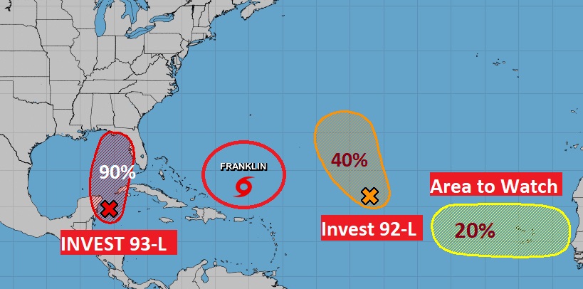
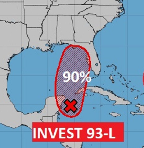
There is now a 90% chance 93-L will become a Depression by late this weekend or early next week. Air Force Recon is expected to investigate this system Sunday, as it enters the southern Gulf in the Yucatan channel. This system will certainly become at least a Tropical Storm as it evolves northward in the eastern Gulf. The next available name is IDAILIA. The I name storms have a bad history. More I name storms have been retired than any others. Most models take this system to tropical storm status early week. But, keep in mind the crazy hot Gulf water temps. (SST). That worries me.
INVEST 93-L POSSIBLE SCENARIOS: The Euro model has been very consistent. It tends to “like” the northeast Gulf Coast. The Big Bend area. Here’s the Euro operational wind “swath” and the Ensemble member tracks.
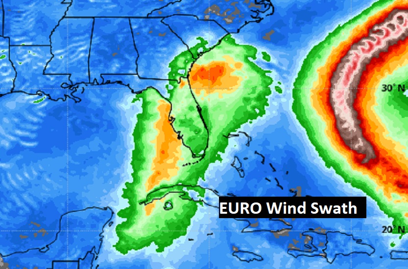
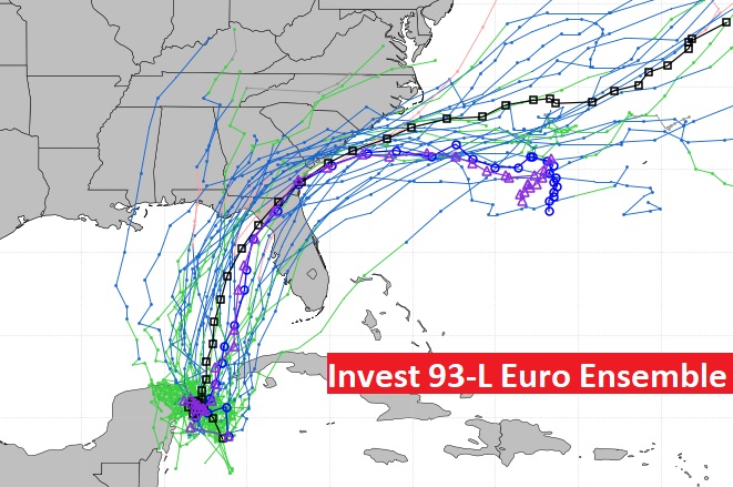
Most tropical models agree with the Euro on that scenario.
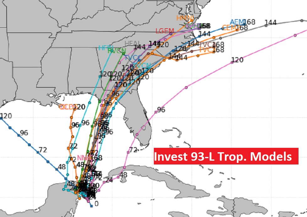
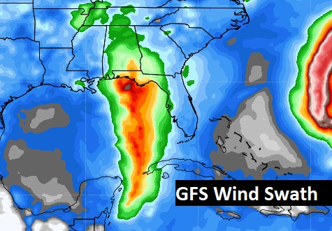
However, the American GFS model is LEFT of that track. Obviously, we don’t like that. Here’s the GFS wind swath and the ensemble model plots.

I favor the EURO. I think the GFS is too far LEFT. But, time will tell. We really won’t get a good handle on this until the system actually comed together, and the RECON data gets plugged into the models. Stay tuned. I’ll keep you up to date.
This is your WEEKEND Blog update. I’ll have another scaled down update for you in the morning, addressing the GULF Tropical threat. Have a nice weekend!
–Rich