
TORNADO WATCH ISSUED before Noon is now officially over!!
It was an explosive with many tornado warnings and unfortunately there have been multiple fatalities reported in Lee county near the Beauregard community. Damage is massive. Still unfolding disaster scene following a large wedge tornado.


14 Tornado reports so far

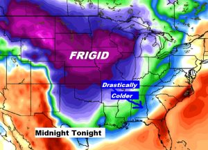
Now the Cold front which brought the storms will usher in drastically colder air
SUNDAY UPDATE: Severe Weather Threat Today – Drastically Colder Air Ahead
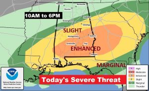
Concern over today’s severe weather threat has increased a notch. There will be severe thunderstorms in the state today. Damaging wind gusts of 60+ mph are possible, along with the threat of tornadoes. The threat could even begin as early as this morning across southwest Alabama. The threat will continue across much of central and south Alabama through the afternoon, and shifting to southeast Alabama by late afternoon and into the early evening. The greatest threat for severe thunderstorms and tornadoes will be from about US 80/I-85 southward where the Storm Prediction Center has an Enhanced risk. Our Weather App will instantly alert you to severe weather watches and warning, wherever you are. Please download it if you don’t already have it. Go to the App Store and Search Rich Thomas Weather.
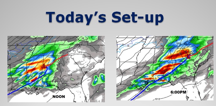
THE SET-UP: Surface low pressure , will track from central Mississippi to near Tuscaloosa by Noon, and then move eastward across Alabama, into North Georgia by evening. This track will keep much of central and south Alabama in the “juicy” air southeast of the low, setting up a potentially dangerous severe threat.
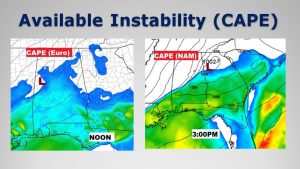
Many of the ingredients for severe weather will be in ample supply, including direction shear or spin for tornadoes and sufficient instability or CAPE.
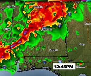
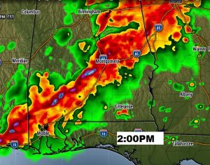
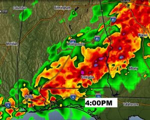
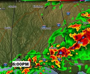
FUTURE RADAR: Don’t take these Future Radar snapshots literally. We use these to get general idea of timing. A little afternoon, severe storms may already be underway in west and SW Alabama. Mid afternoon could be busy with a few supercell thunderstorms embedded in a southward moving line of storms. These storms could easily produce tornadoes. By late afternoon and early evening the drama shifts to southeast Alabama.
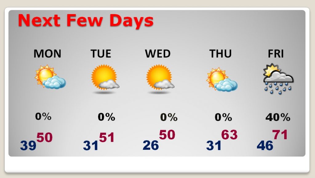
DRASTICALLY COLDER AIR: By late tonight, the showers move out of the state, it will turn wind and sharply colder. We could be in the 30’s by morning. Monday’s high will barely reach 50-52, but winds will make it seem colder. Get ready. Freezing temperatures are a good bet Monday night, Tuesday night and Wednesday night. We may be in the 20’s Wednesday morning. Make plans to protect tender vegetation which may already be budding. Our last freeze was way back on February 1st.
NEXT FEW DAYS: The cold will be around for much of the week, until we start to recover by late week, and then a big warm-up by the weekend. We will be dry until Friday and Saturday.
—
Special note: This is a travel day for me, I’ll be in 3 airports, on two planes. I will have internet access most of the time, and will be posting as much as possible. Our partners at Alabama News Network (CBS 8 /and ABC 32) will be acting in a back-up capacity for me with updates on our Bluewater radio group as needed. You can also watch updates on CBS 8 and ABC 32 with Shane, Matt and Ben.
I’ll have a complete video update Monday morning. I’ll go into much more detail about the much colder week ahead. Stay weather aware today.