1PM UPDATE:
 #Dorian now finally showing signs of picking up some forward speed…now moving NW at 5 mph. Still Cat. 2 with 110 mph winds, on the 1PM update, 105 miles east of Ft. Peirce, Florida
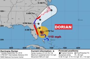
11AM EDT DORAIN UPDATE:
..Dorian finally moving northwestward and growing in size..
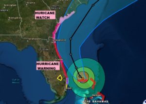
Dorian now at Cat 2 Hurricane, with 110 mph winds, Moving NW at 2,. (Speed will increase later today) Pressure 955mbs., located 45 miles north of Freeport, Grand Bahama. New Hurricane warning issued for SC coast. Getting bigger: hurricane winds 60 miles from center, Tropical Storm force winds 175 from the center.

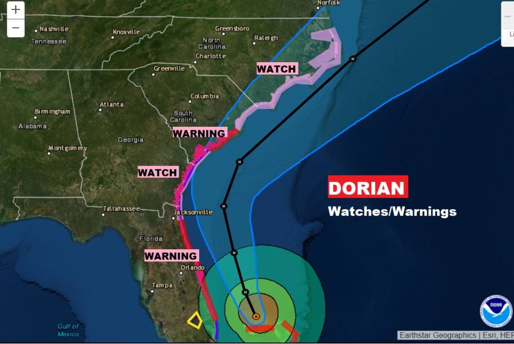
UPDATED WATCHES & Warnings:
EARLY MORNING UPDATE AND VIDEO:
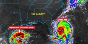
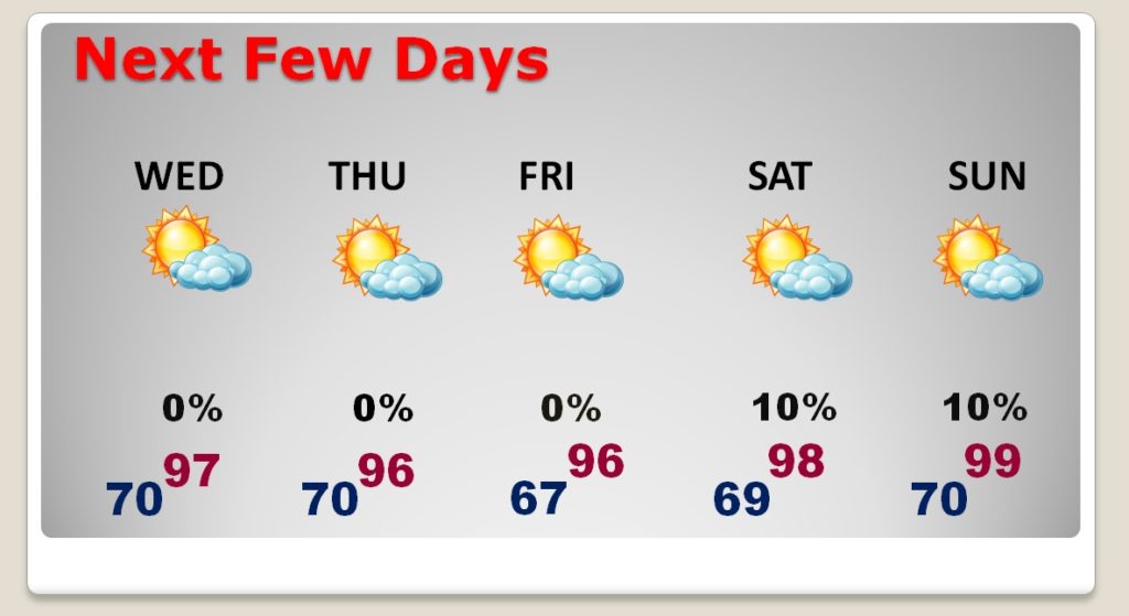
Good morning! The news on Dorian has been absolutely horrific. The human suffering in the Bahamas since Sunday is unimaginable. Today, Dorian will move closer to the Florida coast, moving northward today & Wednesday and then will parallel the Georgia coast, and head for the Carolinas. For us, we will be stuck in a HOT and dry pattern for several days. Could we be near 100 by the weekend? It’s not out of the question. When will rain return to our forecast. And, back to the tropics…we could have a tropical depression or tropical storm in the Gulf later today. It’s very busy in the tropics. I’ll cover it all in your Tuesday morning video briefing.
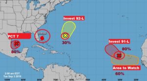
Two Systems..DORIAN off thew Florida coast and brand new PCT 7 in the Gulf. HOT and Dry for us. Heat index near 100.

For us mainly HOT and DRY for several days.
DORIAN still a Major Cat 3 Hurricane stationary over Grand Bahama Island, with winds of 120 mph. Expected to begin mocing soon, and make the curve staying just off the Florida coast.
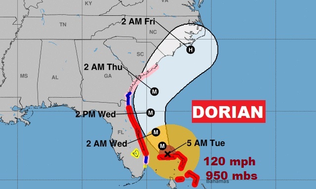
Hurricane Warning along the Florida East coast. Hurricane Watch north to Chareston.
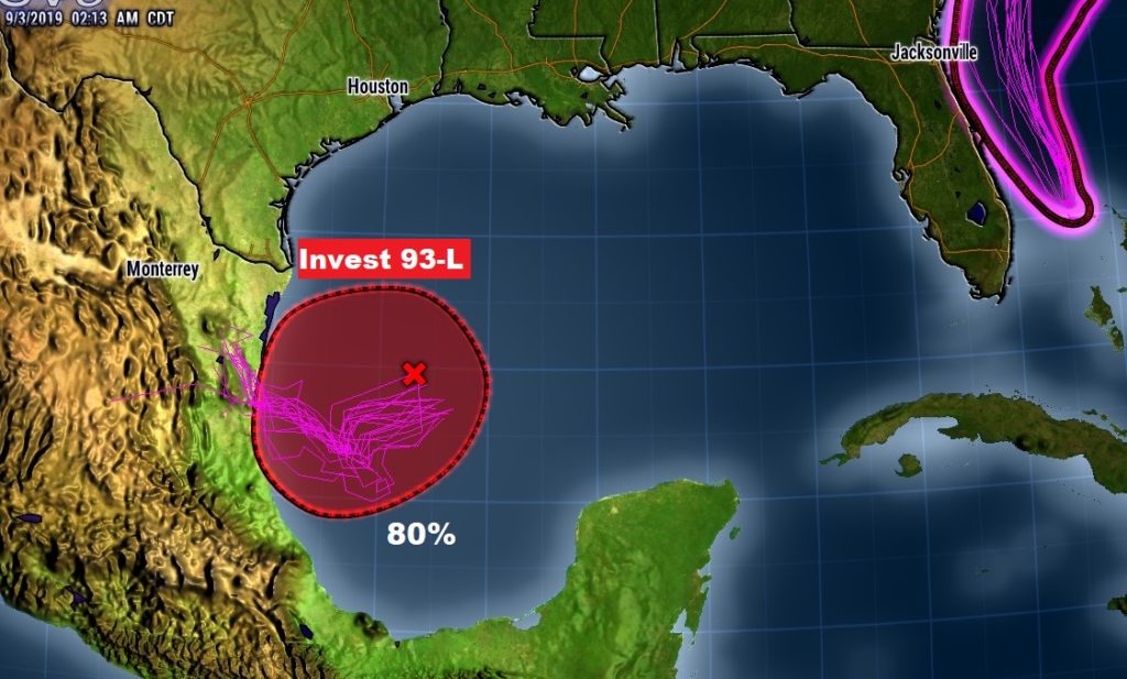
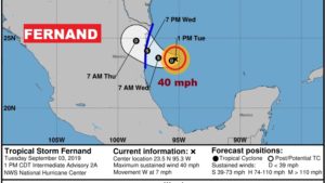
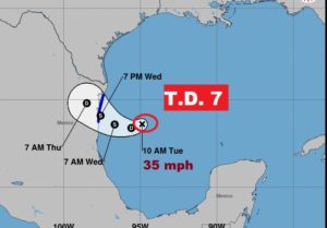
Here’s brand new Potential Tropical Cyclone 7 in the western Gulf. . Could this become tropical storm Ferdand later today? Air Force RECON will investigate. Headed toward Mexico.
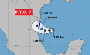
TROPICS very busy. Dorian. Potential Tropical Cyclone 7. Two additional INVEST….one could become Gabrielle. And and Area to Watch.