
4PM UPDATE:
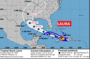
4PM UPDATE: Laura, is still dealing with interaction with Hatti, continues rapidly moving WNW at 21, heading for the Gulf of Mexico Tuesday. Expected to become a hurricane in the Gulf and possibly make landfall on the U.S. Northwestern Gulf Coast late Wednesday as as Cat 2 hurricane. #Laura
10AM NHC UPDATE:
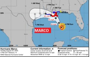
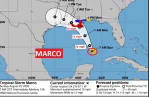
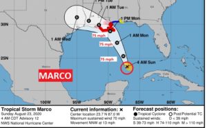
Marco, with winds of 70 mph is not quite a hurricane yet. Expected to become a Cat 1 hurricane today and make landfall along the SE Louisiana coast Monday. Tropical storm watch for the Alabama coast. It’s moving NNW at 13 in the S Central Gulf.
11AM NHC UPDATE: Laura is a 50 mph Tropical Storm over Haiti, reaching the Gulf Monday night, where it will become a hurricane. Potentially a Cat 2 hurricane by Thursday morning landfall over the Northwestern Gulf Coast, roughly 60 hours after Marco’s Landfall as a Cat 1 hurricane Monday.
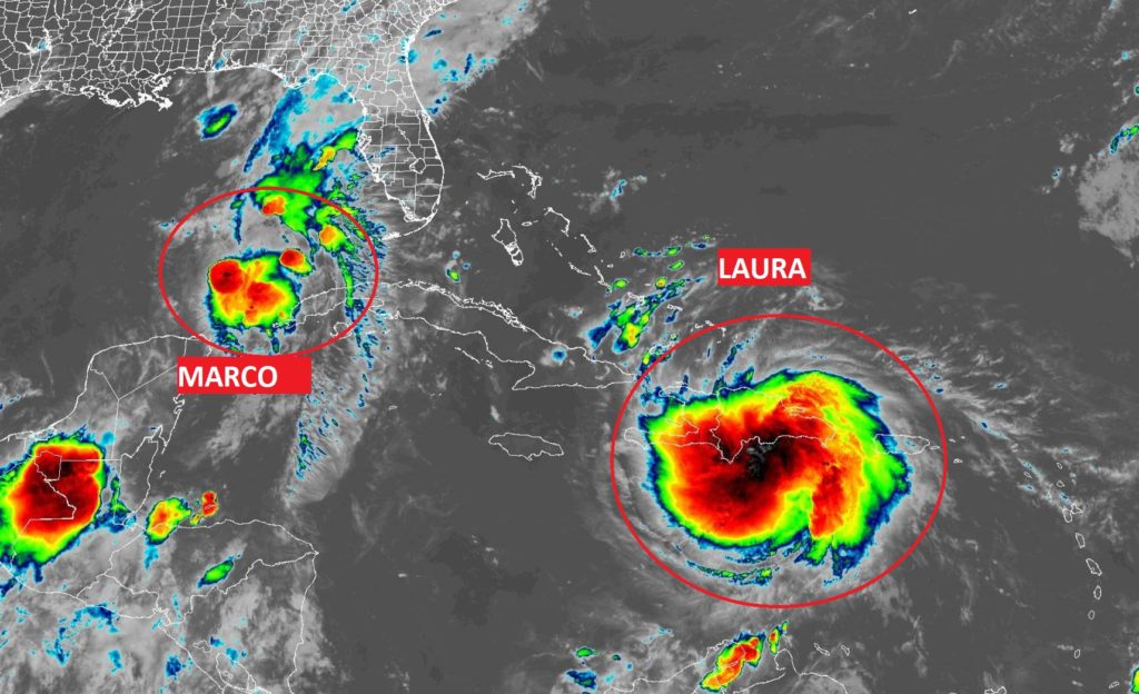
Marco, close to hurricane status is located over the Gulf. Large is that large cloud mass interacting with Haiti. Both destined for landfall along the northern US Gulf Coast this week. Marco Monday afternoon, Laura Thursday morning, about 60 hours apart. Historic. Almost unprecedented.
EARLY MORNING UPDATE:
…A historic and dangerous chapter in weather history is about to unfold this week along the northern Gulf coast, as two landfalling hurricanes aim for the Louisiana coast, perhaps 60 hours apart. All eyes on the future track of Marco and Laura.
A Tropical Storm Watch is in effect along the Alabama coast. The effects on the state of Alabama from Marco and Laura depend on the exact track. Any eastward shift of the track could make a big difference, especially on the potential tornado threat. Much more on both storms below.
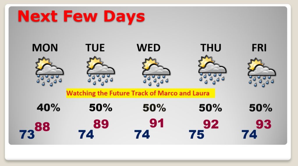
In the short term, our forecast is fairly routine with more scattered showers and thunderstorms.
TODAY: Partial sunshine. There will be a generous supply of showers and thunderstorms, especially this afternoon and this evening. Highs in the upper 80’s to near 90. Low tonight 73. Coverage on the storms today 50-60% ..easy.
NEXT FEW DAYS: Needless to say, our forecast this week is extremely dependent on the future track of Marco and Laura. For now, I’ll play it cautious with a 50/50 storm threat each day, subject to review.
TROPICAL STORM MARCO: At 4AM, Marco is a 70 mph tropical storm in the south central Gulf, moving NNW at 13. Expected to become a hurricane soon, probably later this morning in the warm Gulf waters, in a minimal wind shear environment. Marco could make landfall Monday afternoon along the SE Louisiana coast, probably as a Cat 1 hurricane.
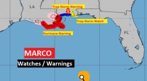
The Hurricane Warning along the Louisiana coast includes the city of New Orleans. Tropical Storm Warning for the Mississippi coast. Tropical Storm Watch for the Alabama coast.
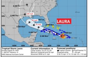
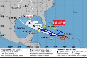
TROPICAL STORM LAURA: Laura is a 45 mph is 95 miles east of Port Au Prince, Haiti, moving WNW at 18. It’s on a course that will take it near or over Cuba and into the Gulf. Expected to become a hurricane in the central Gulf. It could be a Cat 2 hurricane with 100 mph winds late Wednesday night on the Louisiana coast. This landfall will be only about 60 hours after the Marco landfall. Truly historic and shocking.
—
I’ll have a complete video update for you tomorrow morning. Sd have much to talk about I’ll have new information from the National Hurricane Center.
Stay safe and well. Enjoy your Sunday!
–Rich