
Good Morning! A warm front has advanced northward to the Tennessee border. That will lead to very warm & humid day to day. High in the 80’s
But, a strong front, moving across the state on Sunday, will bring yet another round of strong storms to Alabama. Another Severe Weather Threat. This time, though, the tornado risk is low. The main threat is damaging wind gusts.
TODAY: More clouds than sun. Warm & humid for March. Summer-like.) High in the mid 80’s. (normal high 72) Small risk of showers (maybe a thunderstorm?) today and tonight. Low tonight 67. (Full “Worm” Moon Tonight)
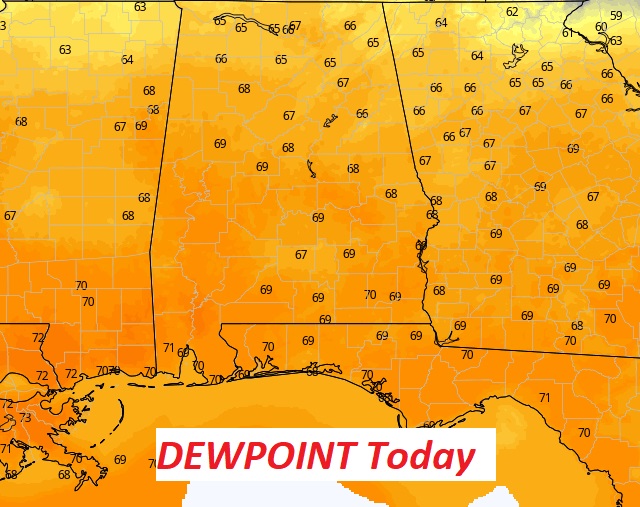
OUCH. It will feel VERY humid today. Dewpoints will be near 70 in central and south Alabama. Sticky. June-like warmth.
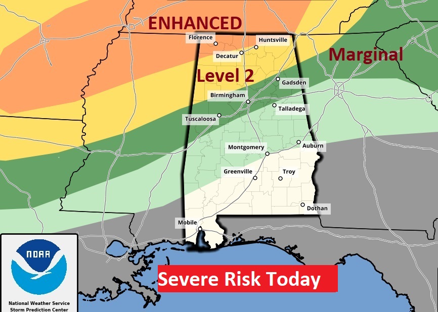
The main severe weather threat stays northwest of us today. Here’s the severe weather threat today through 7AM Sunday morning.
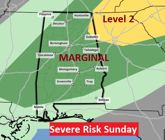
SUNDAY: Marginal Severe Weather Risk. A cold front will advance through the state. Some stronger, possible servere storms are possible, as a line of storms sweeps across the area. Damaging winds are the main risk, this time. Looks like a very low-end tornado threat. High 78. Much cooler Sunday night. Lows will fall to the 40’s.
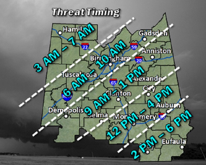
Here’s the Severe Weather Risk Map. The line of storms will reach the Birmingham Metro between 6 and 9AM, Montgomery area between 12 and 2PM, and southeast Alabama by about 5 and 6PM.
For those of you asking specific timing questions for specific times for tomorrow’s strong storms….this map will help.
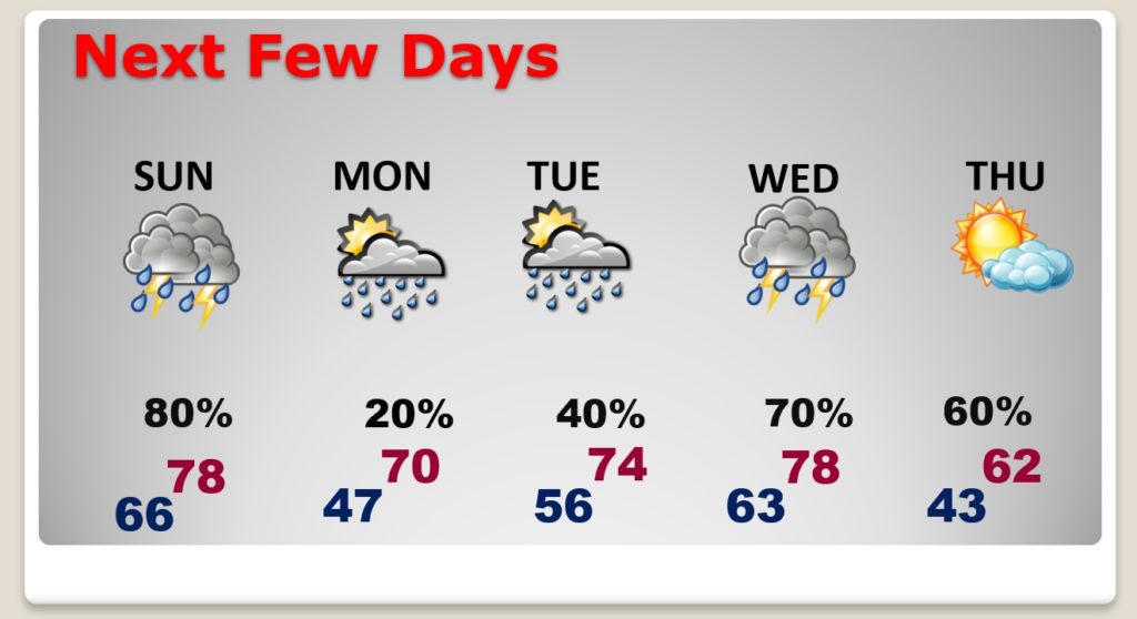
NEXT FEW DAYS: Risk of strong storms Sunday. Much cooler Monday. Much of Monday will be nice. High near 70. Small rain risk. Showers and storms by late Tuesday into Wednesday. Can’t rule out some strong/severe storms Wednesday. MUCH cooler Thursday. We may be in the 30’s by Thursday night.
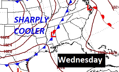
Here’s the set-up on Wednesday.
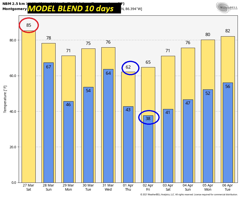
Check out some of the ups and downs in the next 10 days. Warmest day today. MUCH cooler, low 60’s Thursday. Upper 30’s Friday morning.
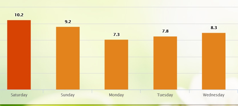
POLLEN COUNT: According to pollen.com…high pollen count today.
TORNADO SURVEYS FROM MARCH 25th CONTINUE: Tornado surveys from last Thursday’s horrific and deadly tornado outbreak will continue for several days. So far, one EF-3, one EF-2, three EF-1’s and one EF-0 have been surveyed. The EF-3, shortly after 1PM, affected Shelby & Saint Clair County. That cell went on to cause the fatalities in Calhoun county. The other strong tornado (EF-2) was in Pickens county. Here’s a link to the ongoing surveys from the NWS Birmingham. Strongest tornado surveyed so far was over in Georgia. Newnan, GA., just SW of Atlanta had a devastating EF-4 tornado with 170 mph wind.
https://nwschat.weather.gov/p.php?pid=202103270258-KBMX-NOUS44-PNSBMX
WEATHER APP SEVERE ALERTS ISSUES: We have an excellent weather app. It is managed NOT BY US, but the instant Severe Weather Alerts come from folks who manage the app at IBM. Apparently, their system was overwhelmed with the volume of severe weather Thursday and March 17th. Apparently, some alerts did not reach the app. They have PROMISED this problem will NOT happen again.
Here’s the reply from IBM…the folks who manage our APP:
• Last night’s issues with non-delivered and delayed alerts was caused by their servers being overwhelmed with the volume of alerts coming in from NWS.
• The issues were across-the-board, potentially affecting all devices regardless of platform.
• The issue was discovered too late to correct it in the moment, but when they added capacity toward the end of the event, a backlog was triggered, resulting in the delivery of old alerts.
• This occurred after a reconfiguration of how the alerting platform works. They say they thought they had tested thoroughly, but admitted that was incorrect.
• They are reconfiguring their alerting platform again to add additional capacity and to introduce dedicated servers to handle individual tasks to avoid recurrence.
• They are stress-testing after adding that new capacity.
• They are alerting support team members to be on heightened awareness around large-scale severe weather events.
HOPEFULLY THIS ISSUE WILL NOT SURFACE AGAIN! Most stations use the IBM managing system for their Apps. Thank you for your understanding. It’s NOT US.
.
There will be another blog update in the morning. Have a nice weekend!
–Rich