There is much interest in the progress of Dangerous Historic Hurricane Florence. At 4PM, the storm is located 100 miles ESE of Wilmington, NC. It’s forward movement has slowed to a snails pace, west northwest at 5. Maximum winds have decreased some to 100 mph, but this is a huge hurricane with hurricane winds extending 80 miles from the center and tropical storm force winds out 175 miles from the center. Here’s the latest from the Hurricane center advisory.
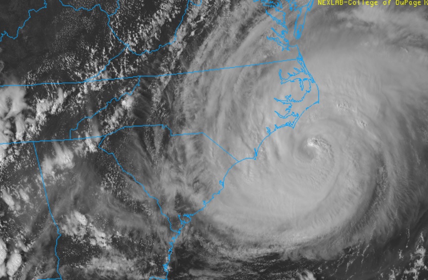
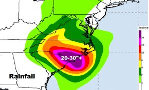
DISCUSSION AND OUTLOOK
----------------------
At 500 PM EDT (2100 UTC), data from NOAA Doppler weather radars
indicate that the center of the eye of Florence was located near
latitude 33.7 North, longitude 76.2 West. Florence is moving toward
the west-northwest near 5 mph (7 km/h), and this general motion is
forecast to continue into Friday. A slow westward to west-
southwestward motion is expected Friday night and Saturday. On
the forecast track, the center of Florence will approach the coasts
of North and South Carolina later tonight, then move near or over
the coast of southern North Carolina and northeastern South Carolina
in the hurricane warning area on Friday. A slow motion across
portions of eastern and central South Carolina is forecast Friday
night through Saturday night.

Doppler radar data indicate that maximum sustained winds have
decreased to near 100 mph (155 km/h) with higher gusts. Little
change in strength is expected before the eye of Florence reaches
the coast, with slow weakening expected after the center moves
inland or meanders near the coast. More significant weakening is
forecast on Saturday as Florence moves farther inland over central
South Carolina.

Hurricane-force winds extend outward up to 80 miles (130 km) from
the center and tropical-storm-force winds extend outward up to 195
miles (315 km).  A NOAA reporting station at Cape Lookout, North
Carolina, recently reported a sustained wind of 68 mph (109 km/h)
and a gust to 85 mph (137 km/h).

The estimated minimum central pressure is 955 mb (28.20 inches).


HAZARDS AFFECTING LAND
----------------------
STORM SURGE:  The combination of a dangerous storm surge and the
tide will cause normally dry areas near the coast to be flooded by
rising waters moving inland from the shoreline.  The water has the
potential to reach the following heights above ground...

Cape Fear NC to Cape Lookout NC...7-11 ft, with locally higher
amounts in the Neuse, Pamlico, Pungo, and Bay Rivers
Cape Lookout NC to Ocracoke Inlet NC...6-9 ft
South Santee River SC to Cape Fear NC...4-6 ft
Ocracoke Inlet NC to Salvo NC...4-6 ft
Salvo NC to North Carolina/Virginia Border...2-4 ft
Edisto Beach SC to South Santee River SC...2-4 ft

The deepest water will occur along the immediate coast in areas of
onshore winds, where the surge will be accompanied by large and
destructive waves.  Surge-related flooding can vary greatly over
short distances.  For information specific to your area, please see
products issued by your local National Weather Service forecast
office.

RAINFALL: Florence is expected to produce heavy and excessive
rainfall in the following areas...

Southeastern coastal North Carolina into far northeastern South
Carolina...20 to 30 inches, isolated 40 inches. This rainfall will
produce catastrophic flash flooding and prolonged significant river
flooding.

Remainder of South Carolina and North Carolina into southwest
Virginia...6 to 12 inches, isolated 15 inches. This rainfall will
produce life-threatening flash flooding.
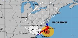
Take a look at Florence’s odd forecast cone and note how the storm doesn’t move much for the better part of three days as it lashes the coast relentlessly.
Prolific rainfall amounts are expected along with the threat of tornadoes, too.
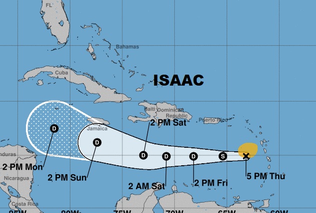
Meanwhile here’s the latest Forecast Cone on Isaac, moving into the Caribbean Islands.