
The forecast for the next 7 days is complicated. I could get overly “wordy” on the fine details, but I won’t. I’ll condense.
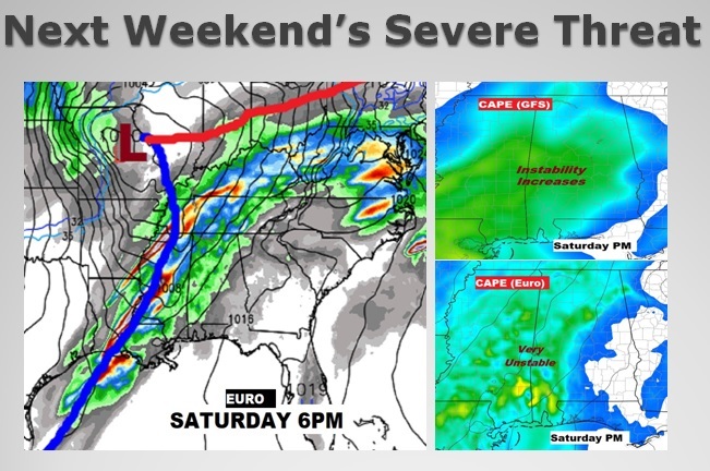
A series of storm systems will swing through the Gulf States, one after another. The first one is today. We get a nice break tomorrow in between storm systems. Tuesday through the end of the week look very wet, indeed. The “caboose” of this weather pattern will come next weekend, with a storm system that could produce severe storms. As you will see, parts of north Alabama are expected to receive serious rainfall totals which could cause flooding, as a frontal system stalls across that part of the state.
TODAY: We’ll in the warm air south of a warm front. Cloudy. Scattered showers. Can’t rule out some ruble of thunder. Breezy. High upper 70’s Showers and thunderstorms become more likely tonight. Overnight low 52.
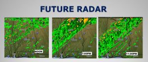
Here’s a few Future Radar snapshots showing the spotty nature of the showers across south Alabama with more concentrated rain to the north. The better rain chances shift southward tonight.
NEXT FEW DAYS: Monday (President’s Day) is the “pick of the litter” as the best weather day this week. It’ll be partly sunny with highs in the 60’s.

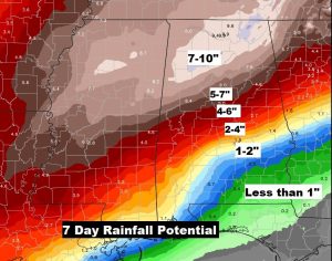
EXCESSIVE RAINFALL POTENTIAL: What sticks out on this map below is the excessive 7-10” potential rainfall totals across North Alabama, particularly Wednesday through Friday. The amounts drop off quickly as you move south. We could easily see 2-3” totals even as far south as I-85. South Alabama will see lighter amounts.
SEVERE WEATHER THREAT THIS WEEK?: I’ll be brief. There are a few windows of opportunities Wednesday through Friday, when the Storm Prediction Center could introduce Marginal Severe Weather threats for parts of the state. The weather system that concerns me the most arrives this weekend. It appears many of the necessary severe weather ingredients will be available. We’ll watch this unfold as the week goes on.
SEVERE WEATHER AWARENESS WEEK: Today is the first day of Severe Weather Awareness Week in Alabama. Now is the time to meet with your family and come up with a plan of action. Know where your county is located on the map.
Identify your Home’s safe spot. Typically it’s a small enclosed room or substantial hallway on the lowest level, far away from windows. Put as many walls between you and the outside as possible. Have at least two reliable methods of getting a warning, like a weather app on your phone and a weather radio that can wake you up in the middle of the night. Review safety plans. I have a link to the National Weather Service Awareness plan below.
https://www.weather.gov/bmx/outreach_feb2019
PRATTVILLE TORNADO 2008: it was a miracle, on this day 11 years ago. Like today, it was a Sunday, 3PM, when an EF-3 tornado tore through Prattville causing extensive damage in many neighborhoods. Fortunately, nobody died. Truly a miracle.

—
I’ll have a complete video update Monday morning at 4:45AM. Have a great Sunday!
Rich