
Tornado Watch issued until 6:00 am Monday, April 13th, for Central and Southeast Alabama to the Georgia State line. Damaging wind gusts to 70+ mph and Large hail possible.
00 am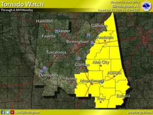
EARLY MORNING UPDATE:
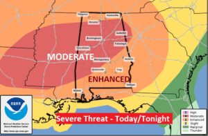
We, unfortunately, will be dealing with a rather significant Hi-impact Severe Weather Event today and tonight. The risks include damaging wind gusts 70+ mph, golfball size hail, and tornadoes are probable in Alabama today. There could be a few strong, long tracked tornadoes. There is still some substantial question marks. For instance, will there be a Round One this afternoon. MAYBE. IF storms can get going this afternoon, in the warm, increasingly humid, they could rapidly become severe with damaging wind gusts, and possible tornadoes. The MAIN round of severe storms will sweep across the state tonight, along a broken line of super-cell thunderstorms which will produce widespread damaging winds, tornadoes, and large hail. That window for the main event will extend from early evening through the wee hours of the morning, exiting SE Alabama at perhaps 4AM.
SEVERE WEATHER RISK TOADY/TONIGHT: This is a very concerning set-up for severe weather. Much depends on whether severe storms do develop in the afternoon, ahead of the Main Event. So called “meso-scale” details will be important. However, MOST of the state is in a Level 4 out of 5 MODERATE severe risk. It has been expanded by the Storm Prediction Center.
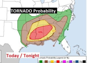
Tornado Probabilities of at least 10% probability, within 25 miles of any point, cover a good bit of of Alabama. But, in the moderate risk area, probabilities increase to a disturbing 15% chance.
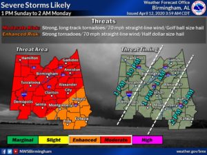
RISK TIMELINE? Unfortunately, because of the unknown factors about the afternoon hours, the threat window for this event is rather large. Take a look at this NWS graphic on timing.
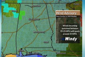
WIND ADVISORY: Outside of thunderstorm areas, it will be quite windy this afternoon and tonight. Wind gusts as high as 35 mph are possible. Wind Advisory from Noon today till 3AM Monday. Might be a good idea to secure lose objects around the yard and patio furniture.
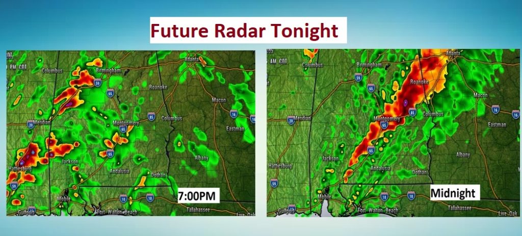
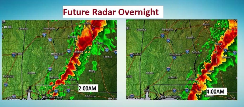
FUTURE RADAR: A few model radar snapshots will give you some sense of how the main thunderstorm line may traverse across the state this evening and tonight. Around Midnight, perhaps, the line will have reached the mid point of the state, perhaps exiting the southeast counties around 4AM or thereabouts.
PUBLIC STORM SHELTERS: Plans for which shelters will be open and the protocol vary widely from county to county. In general, what I can tell you as this. Many Safe Places and “Safer Places” will be open during a Tornado Watch. However, you must wear either a mask or some sort of cloth covering, for everyone’s safety.
BE READY FOR SEVERE WEATHER: Have a plan of action for your family. Be ready to go to your safe place. Wear shoes. If you have helmets…wear them during a warning. You need at least two reliable ways to get a warning. Our weather app could be one. A Weather Radio is a very reliable way to get a warning. It will wake you up when a warning is issued. Do not rely on hearing a weather siren. They are only designed to be heard by those who are outside, and, they sometimes malfunction. Stay in your safe place during a warning. You can watch our LIVE stream on our weather app. Download the App by going to the app store and search Rich Thomas Weather.
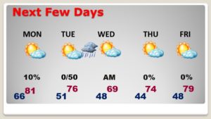
NEXT FEW DAYS: Monday & Tuesday will be nice calm comfortable days. Tuesday will be cooler. A second cool front will deliver a chance of showers Tuesday night. Lows in the 40’s Wednesday and Thursday morning. Quite cool Wednesday afternoon. Warmer late week.
—
I’ll be with you today and tonight. I’ll be in the Bluwater Weather Center. I’ll be updating you our LIVE stream, which you can watch on our weather app or online of You Tube..at Rich Thomas Weather. Plus, we’ll be updating you extensively on social media. I’ll be interrupting on the 8 Bluewater Radio stations as needed. I’ll be helping our TV partners at the Alabama News Network, on CBS 8 and ABC 32. Shane, Ryan and Ben will be interacting with me from time to time on TV.
Just like to Corona Virus, we are all in this Tornado Threat together. We’ll get through this. Stay Weather Aware.
Happy Easter Sunday.
–Rich