
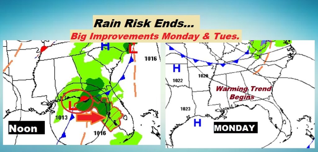
Good Morning! Welcome to the last official day of Fall. The Low along the Gulf coast has brought very light rainfall amounts to many of us, while all the heavy rain and storms have stayed south of the Gulf coast. The rain risk should end this morning.
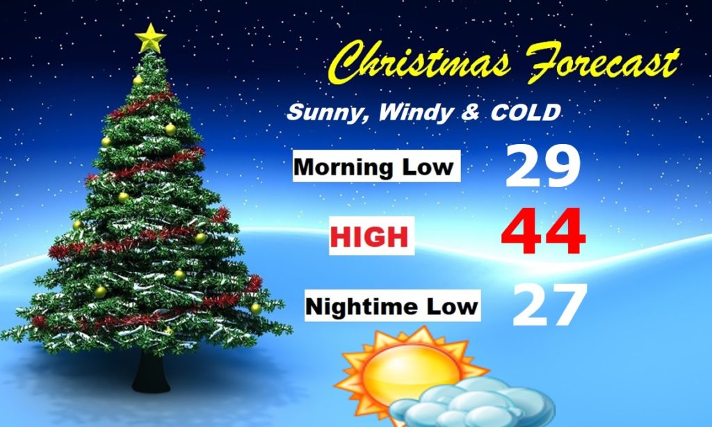
The news is good for Monday through Wednesday, as Christmas week begins. Expect a nice early week warming trend. But drastic changes are on the way. A significant storm system will begin to affect the area Wednesday night & Christmas Eve. Sharply colder air will funnel in behind the storm. Get ready for an Arctic Cold Blast Christmas Eve night and Christmas Day will be COLD. Wind chill will be a factor.
TODAY: Periods of mostly light rain or drizzle, mainly this morning. Mostly cloudy. Near normal high temperature in the upper 50’s. (Yesterday’s high 60°) Low tonight 42. Patchy fog late.
NEXT FEW DAYS: The BEST news this week…a warming trend Monday through Wednesday. Highs 60-65. Showers and maybe some thunder arrive Wednesday night, into Christmas Eve Thursday.
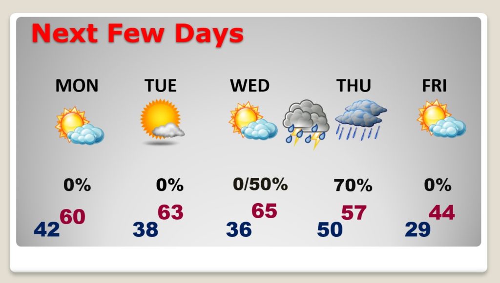
CHRISTMAS WEEK STORM SYSTEM: Showers and maybe some thunder arrives Wednesday night, into Christmas Eve Thursday. There is still about a nine-hour timing difference between two key models. The GFS is fastest, the EURO is the slower solution. That means the cold front moves through either Thursday morning or in the afternoon. At this time, there is no evidence of a Severe Weather threat.
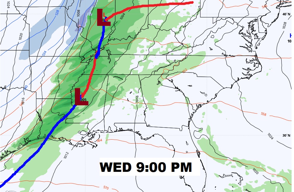
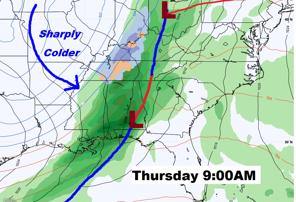
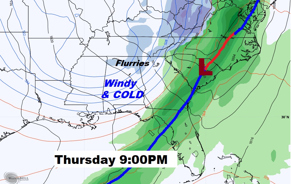
After the cold front passes your location, it becomes windy and dramatically colder. Arctic Air will engulf the state, and much of the southeast. Wind Chill will be a factor Thursday evening/night and Christmas Day. Even a few snow flurries are possible in north and northeast Alabama Thursday night. Can’t rule out a stray snow flake or two farther south, but NOT a big dal.
Christmas Day will be Arctic Cold this year. (Last Year…nice… High 74, low 47)
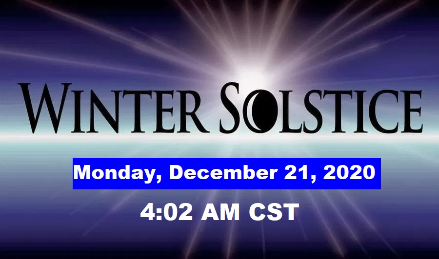
WINTER SOLSTICE: Winter officially begins tomorrow morning at 4:02 AM…the Winter Solstice. South of the Equator, tomorrow is the first day of Summer.
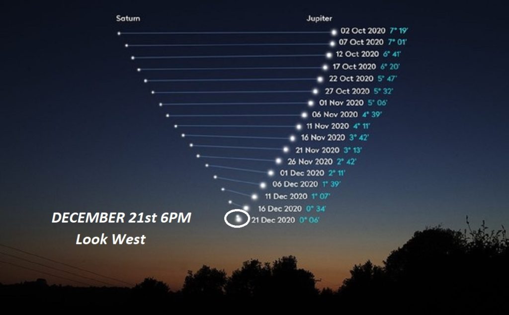
JUPITER/SATURN CONJUNCTION: Our Friend, Rick Evans, Director of Montgomery’s W.A. Gayle Planetarium puts this rare event in perspective. He writes, on Facebook: “There’s been a lot of hype regarding this planetary conjunction of Saturn and Jupiter coming up on Dec 21st. As the news outlets typically do, its being overhyped!!! From calling it the Bethlehem Star, to the Christmas Miracle star complete with pictures of a majestic star outshining everything in the sky. The reports talk about how rare this event is, dating back to the “middle ages.”
The truth is the two planets conjunt approximately every 20 years. The conjunction in the year 1226 was the closest the two would have appeared….but the telescope hadn’t even been invented yet. Ergo no one could have seen it. The next closest was the 1623 conjunction, and it would have been observed by many astronomers.
If you are observing the Dec 21, 2020 conjuction with the naked eye (without a telescope or binoculars) you will see what will look like any other of the brighter stars (Sirius for example) in the winter sky. With all this media hype, I’m afraid you’re likely to be disappointed.
This event is unique for astronomers (amateur or professional) in that they will have the unique opportunity to see two planets (and four moons) through their single eyepiece. That is a rarity, and something we are looking forward too. “ Thanks Rick!
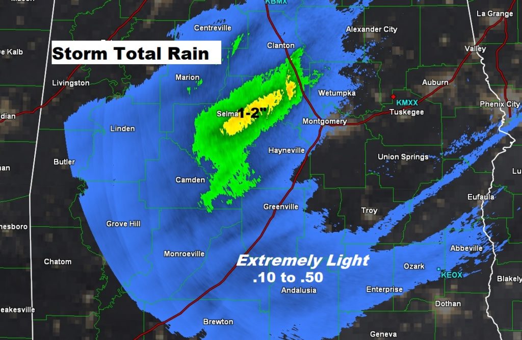
NOT MUCH RAIN: Many towns barely had a tenth of an inch of rain overnight. An exception would be an area of 1-2” rainfall between Clanton and Selma. Here’s Doppler Radar Storm Total estimates.
—
Have a GREAT Sunday! I’ll have a complete video update in the morning.
–Rich