
Good Morning! Here’s my brief video forecast discussion.
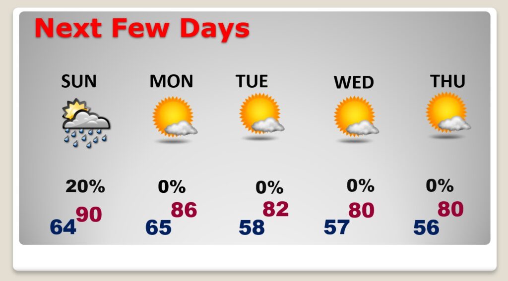
TODAY: This great Fall weather continues today. Great football weather. Sunshine dominates. Comfortable humidity. High in the middle 80’s. Nice easterly breeze at 6 to 12 mph. Mainly Clear tonight. Pleasantly cool. Low 64.
NEXT FEW DAYS: Another front approaches Sunday. Spotty thundershowers are possible in the afternoon/evening ahead of the front. Behind it, Monday will be much more comfortable. In fact, much of next week looks great. Low humidity. Sunshine. Cool nights. Highs in the 80’s. Upper 50’s at night. Nearly perfect.
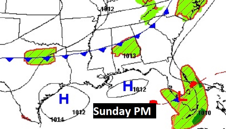
Here’s a snapshot around sunset Sunday evening. That southward moving front could touch off some widely scattered showers and perhaps a thundershower. Much nicer air will follow the front for Monday and much of next week.
TROPICAL OUTLOOK: NHC has it’s handful with FOUR named storms. Powerful Hurricane Fiona is making a historic and devastating landfall early this morning in Maritime Canada. A landfall barometric pressure of 936 millibars was recorded overnight in Nova Scotia. That would be far and away the lowest pressure ever recorded in Atlantic Canada.
Also in the Atlantic basin there is Gaston, Hermine and now Ian…plus one Area to Watch.
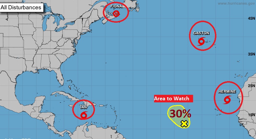
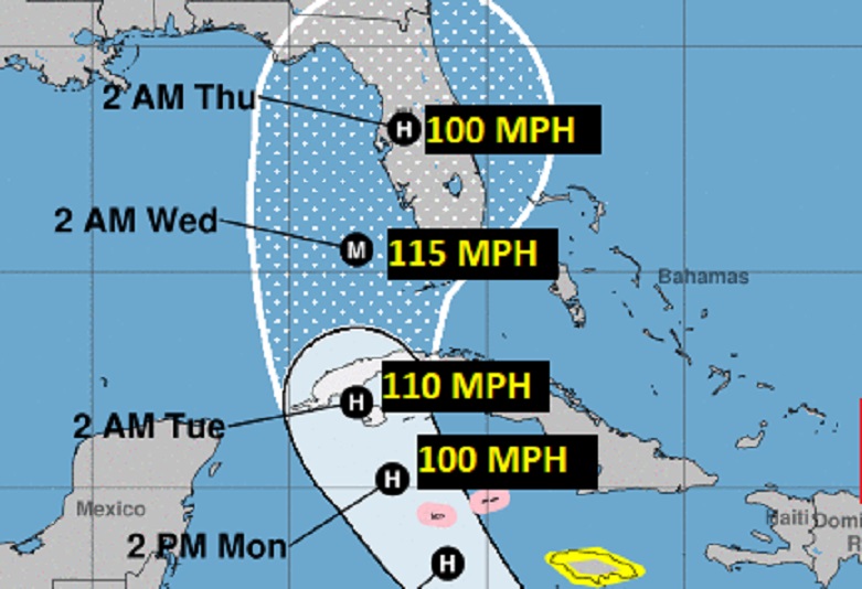
Obviously, All Eyes are on Tropical Storm IAN in the Caribbean. Ian is growing stronger, with winds of 45 mph, moving west at 14.. It is likely to undergo rapid intensification in the northwest Caribbean in the next 36 hours, becoming a hurricane as it heads for the southeastern Gulf of Mexico. The environment and warm Sea Surface temperatures will be very favorable for potential explosive development. Right now the forecast favors Ian becoming a major hurricane, potentially with a huge impact on Florida by early to mid-week.
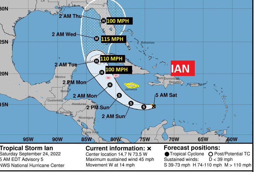
A Closer look at the Cone. NHC has nudged the cone westward and is hinting it may have to nudge it even further westward in future advisories. Stay tuned
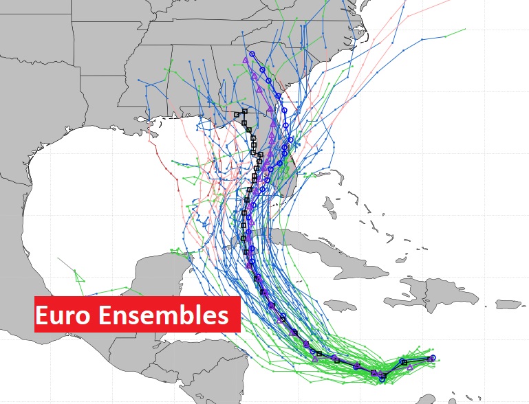
But, COULD Ian stray from the current NHC projected path? Yes. This is not a done deal yet. All of us here in the Gulf south need to stay vigilant as we continue to closely monitor Ian’s future. This is the EURO Model 51 member Ensemble plots. Notice, there are too many of those lines pointing to the central Gulf Coast. Stay tuned.
Here’s the very interesting NHC 4AM CDT technical discussion.
https://www.nhc.noaa.gov/text/refresh/MIATCDAT4+shtml/240853.shtml?
Thanks for reading this Blog this morning! I’ll have another update for you in the morning. Have a nice Weekend!
–Rich