
4:00 PM Update:
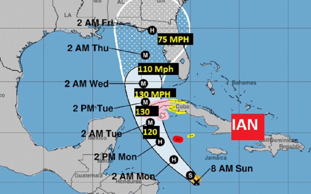
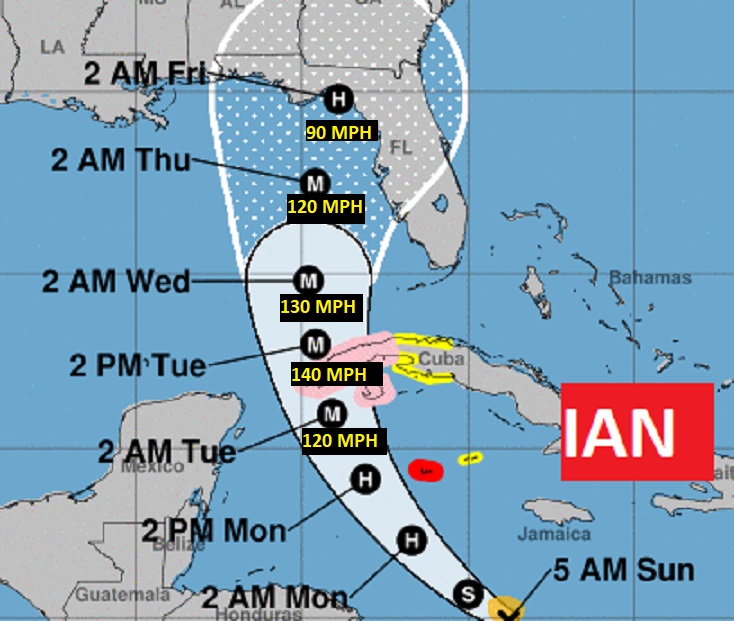
Tropical Storm Ian winds now 45 mph the Caribbean , moving WNW turn at 12. Rapid intensification is likely . NHC forecast shows Ian becoming a hurricane on Monday and a major hurricane on Tuesday. New NHC forecast cone shows the very slightest eastward shift. #alwx
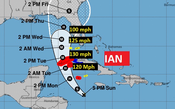
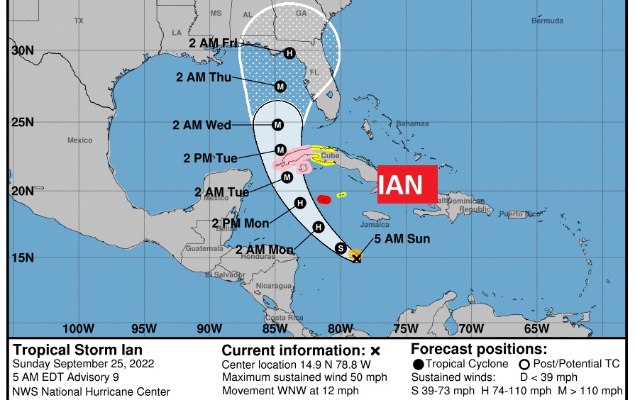
10:AM NHC Update: Ian winds now 50 mph, beginning a WNW turn at 14. Rapid intensification begins later today. Ian will curve into the SE Gulf Tuesday as a Major Hurricane. Significant model spread days 3-5. The GFS is farthest west, the Euro east over the Fla. Peninsula. The NHC cone is in the middle. The SE third of Alabama is now in the cone of uncertainty. #alwx
EARLY MORNING UPDATE:
Good Morning! Here’s my brief video forecast discussion.
CLIMATE DATE: Yesterday’s high only 83.Morning Low 61. Normal 88/64. Sunrise: 6:36, Sunset 6:38.
TODAY: Today will be noticeably warmer. A Sun/cloud mid. Another front will slide southward through the state today and this evening.
Spotty thundershowers are possible in the afternoon/evening ahead of the front. High near 90. Partly cloudy tonight low 66.
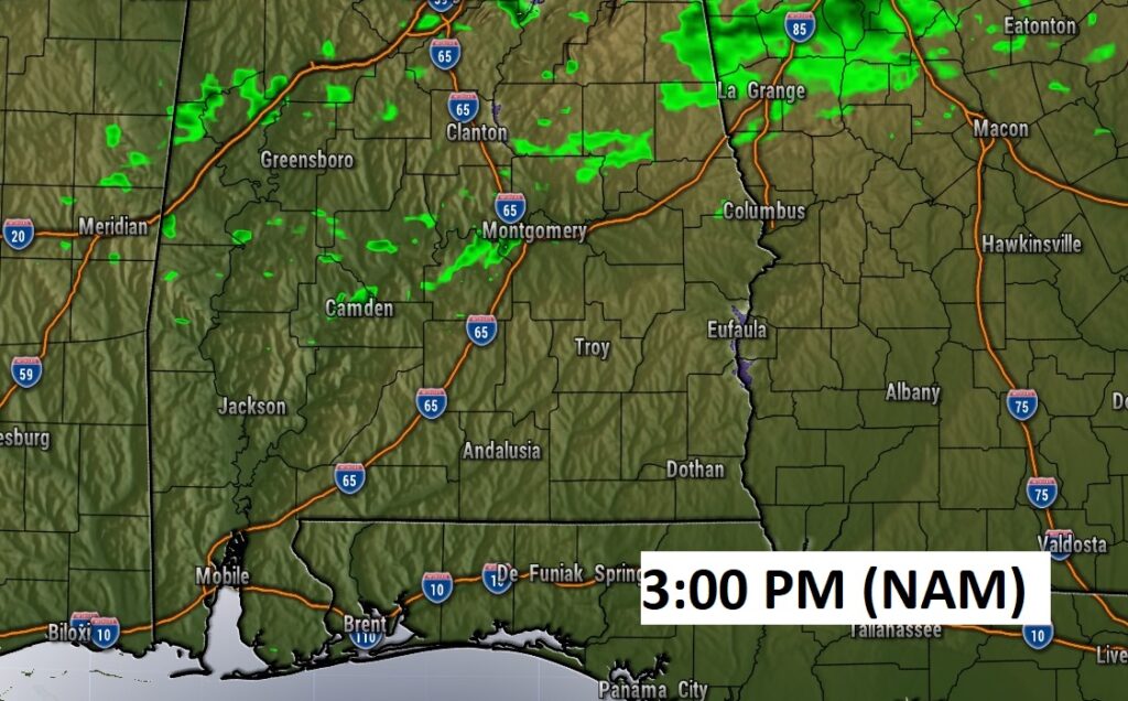
Here’s Future Radar showing a few spotty showers along and ahead of the cool front at mid afternoon.
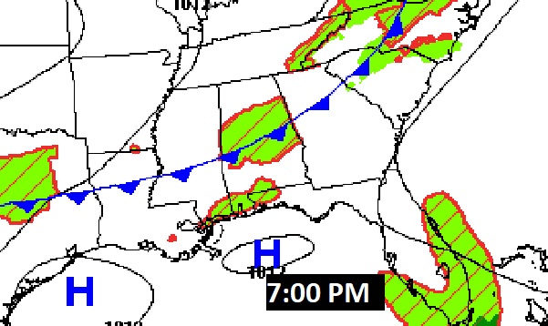
Here’s the expected position of the cool front around 7PM tonight.
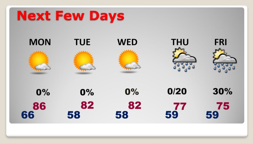
NEXT FEW DAYS: Behind the front, Monday will be much more comfortable. In fact, the weather looks great through mid-week. Comfortable days, cool nights. Highs in the 80’s. Upper 50’s at night. But, our late week weather will be highly dependent on the future track of Ian. Right now, we’ll introduce a chance of showers by Thursday night and a better chance of showers Friday. This forecast is obviously subject to major changes depending on Ian. Highs only in the mid 70’s Friday.
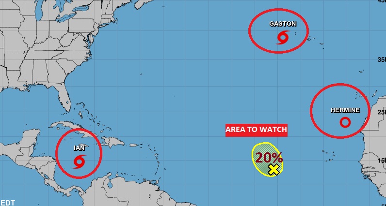
TROPICAL OUTLOOK: National Hurricane Center is still tracking three named systems and one Area to Watch. We only care about one of these – Tropical Storm Ian in the Caribbean.
Ian is growing stronger, with winds of 50 mph. It is likely to undergo rapid intensification in the northwest Caribbean in the next 36 hours, It’s likely to become a hurricane today. It will affect western Cuba by Tuesday morning and move into the eastern Gulf of Mexico The environment and warm Sea Surface temperatures will be very favorable for potential explosive development in the NW Caribbean and the eastern Gulf. It could reach Category 4 status in the Gulf.
Over the last day or two, NHC has been nudging the forecast cone westward. This is concerning. Fortunately, on this 4AM forecast package, they kept the cone essentially the same. Right now it appears the center of Ian will track through the NE Gulf toward Florida. Because of the forecast uncertainty, all of us need to monitor Ian’s future path and development very closely.
RAPID INTENSIFICATION: IAN could reach Category 4 status in the Gulf. Much of southeast Alabama is in the cone of uncertainty.
Thanks for reading this Blog this morning! I’ll have another update for you in the morning. Have a nice Weekend!
–Rich