
Good Morning! Today is the first day of Winter. We get a brief break. The Calm before the drama. More rain by Thursday and Thursday night ahead of an Arctic Cold Front. We have a Bitterly Cold Arctic Blast Shocker on the way for Christmas Weekend. Late Thursday night there will be a shocking temperature plunge. By Friday morning: Low 19, Wind Chill 5. For instance, Friday’s High near 27 would be a record. It will be very windy. Wind chill by Saturday morning could reach ZERO. Saturday’s high will struggle to reach freezing. Christmas Day will be quite cold. It’ll be the coldest Christmas since 1989. The updated numbers are below. Here’s my brief forecast discussion.
TODAY: Calm before the drama. Cloudy, a little breezy but dry. High 55. East wind 6 to 16. Chance of an isolated shower in the overnight hours tonight. Low 44.
WINTER SOLTICE TODAY: Winter Officially begins at 3:48 PM CST. Shortest day of the year: 10 hours, 1 minute, 33 seconds. Today is two seconds shorter than yesterday. Tomorrow is 1 second longer than today.

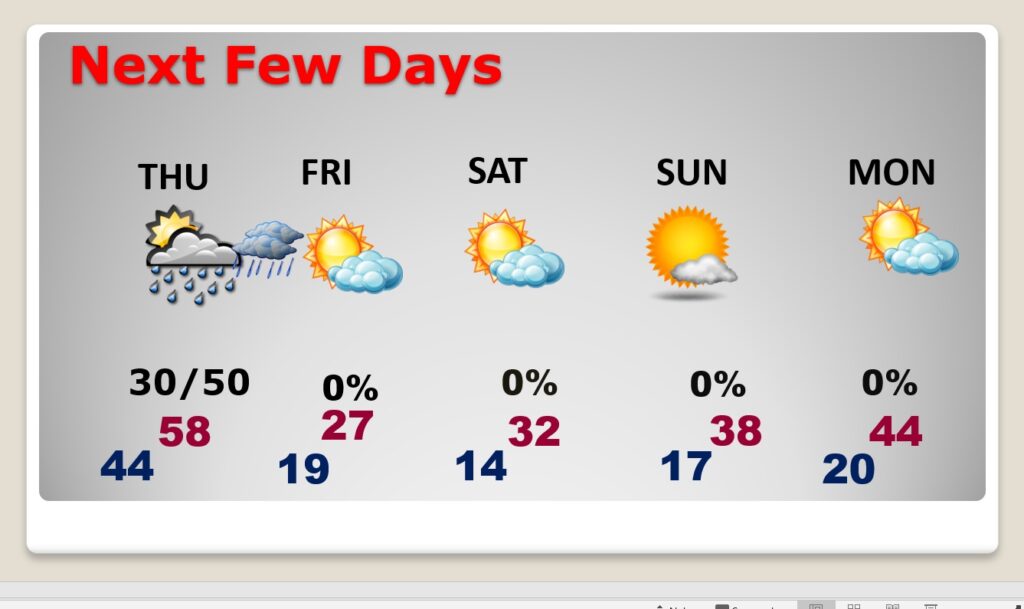
NEXT FEW DAYS: Showers at times Thursday and Thursday night, till about Midnight. Then, Windy and sharply COLDER overnight Thursday night. Shocking temperature plunge overnight. Friday’s forecast is FRIGID. Morning low 19, wind chill 5. (winds gusting as high as 40 mph) High of 27. VERY WINDY. Low 14 by Dawn Saturday. Wind chill by Saturday morning, near ZERO for many of us. Saturday’s high not too far from freezing. A COLD Christmas day. Roughly 30 degrees colder than last year. Monday: Sunny and dry, but the high will only reach 44.
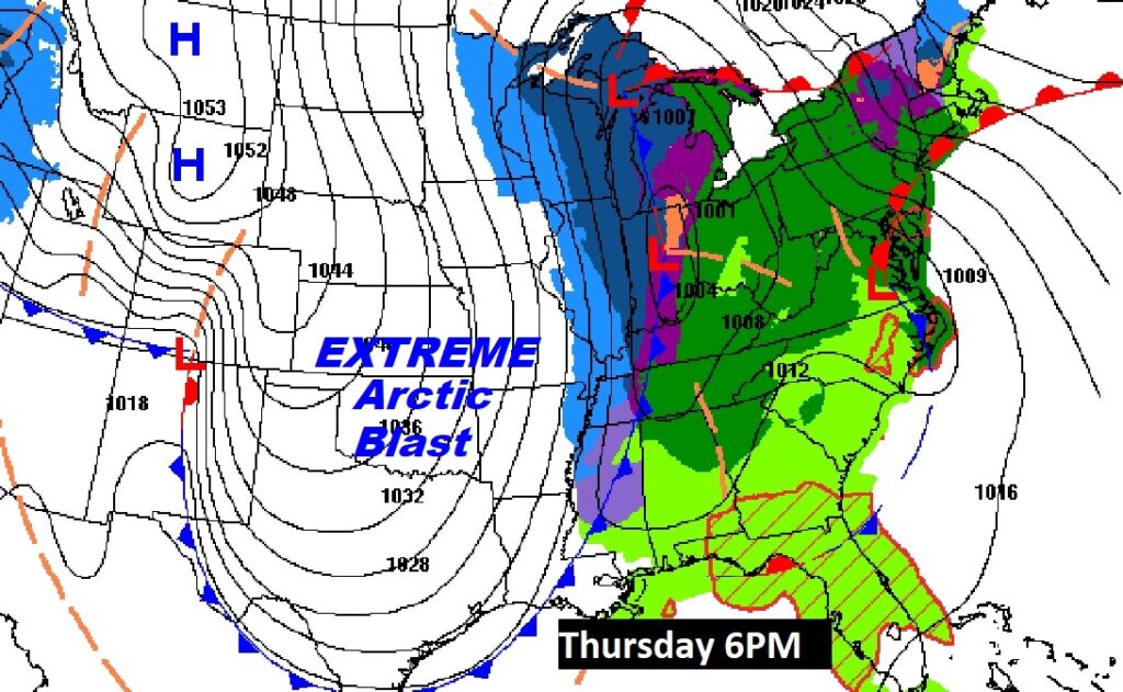
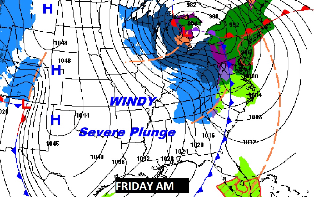
Here’s the Map for Thursday night and Friday. BAD news for holiday travelers. A Blizzard will be underway across the Mid west and Great Lakes. All those lines are called ISOBARS. The More isobars, the stronger the wind. Wind will be a big story with this historic Severe Arctic Invasion.
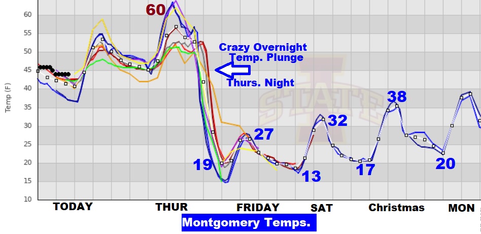
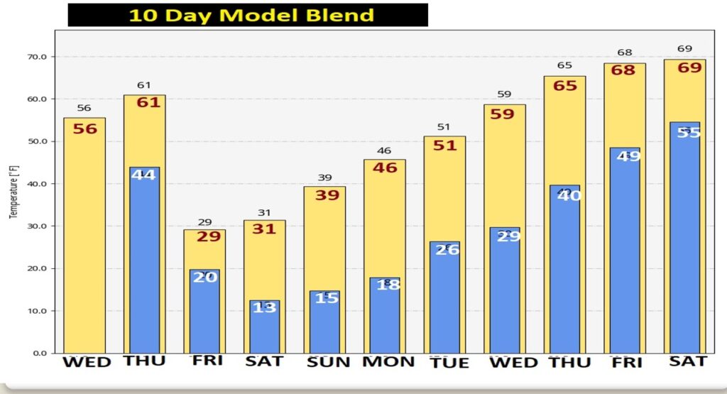
This temperature graph speaks volumes. Thursday’s high near 60. Crazy temp. plunge overnight Thursday. Friday AM low 19. If we fail to go above 32 Saturday, Montgomery could be at or below freezing for 35 hours straight till 11AM Christmas. Crazy rare! Winter is coming.
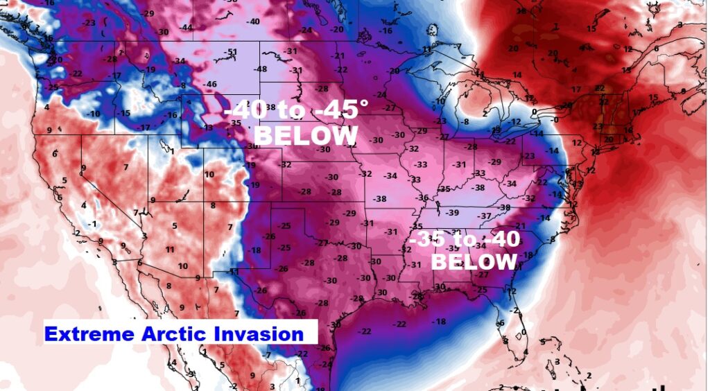
By Friday, many of us in the South will be enduring temperatures 30 to 35 degrees below normal. Stupid-cold. Dangerous. This map is a SHOCKER. We started talking about this three weeks ago But, back then, it just looked too shocking to be true. Now, it’s almost on our door step.
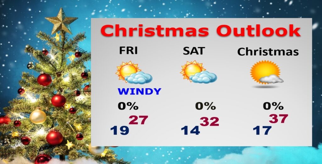
Here’s your updated Christmas Weekend Forecast. At least we won’t have to deal with any snow or ice to worry about.. That’s the best news. No travel issues.
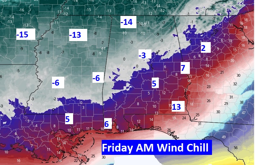
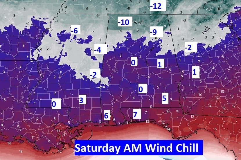
Take a look at projected Wind Chill numbers across the South on Friday and Saturday. Crazy numbers. Shocking. This is serious, dangerous Arctic COLD. Get ready.
But, hang on. I like what I’m seeing on the 10 day model temperature trend. By late next week, highs recover to the upper 60’s. We could flirt with 70 degrees on the last day of 2022. That will be a NICE turn-around.
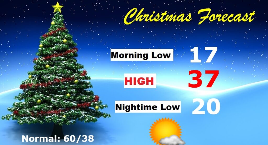
CHRISTMAS OUTLOOK: Get ready for Christmas in the Arctic. Morning low in the upper teens. AM. Wind Chill near 10. Daytime high perhaps mid 30’s. Mostly sunny. Nighttime low near 20. Normal of 60, and last year’s 77! No snow or ice to worry about, though, so travel will not be a problem.
Thanks for reading this Blog this morning! This morning we are LIVE on the radio from 6 to 9 on NewsTalk 93.1. Watch us on TV on CBS 8 and ABC 32. I’ll have another update for you in the morning. Have a nice day!
–Rich