
11:30 AM UPDATE:
GREAT NEWS from our partners at NWS Birmingham: At this time, we don’t anticipate a Watch being issued for Central AL. Based on data from the special balloon release & other mesoscale parameters, conditions just aren’t supportive of widespread severe weather. Winds will remain strong outside of storms. Today’s severe weather threat now appears to be very small indeed. Thankfully.
EARLY MORNING UPDATE:
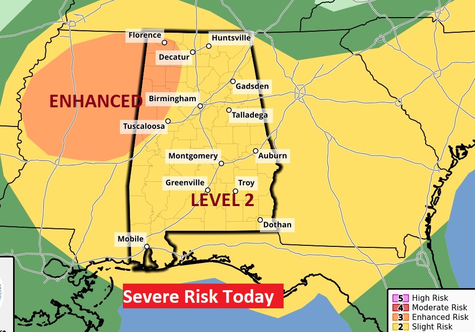
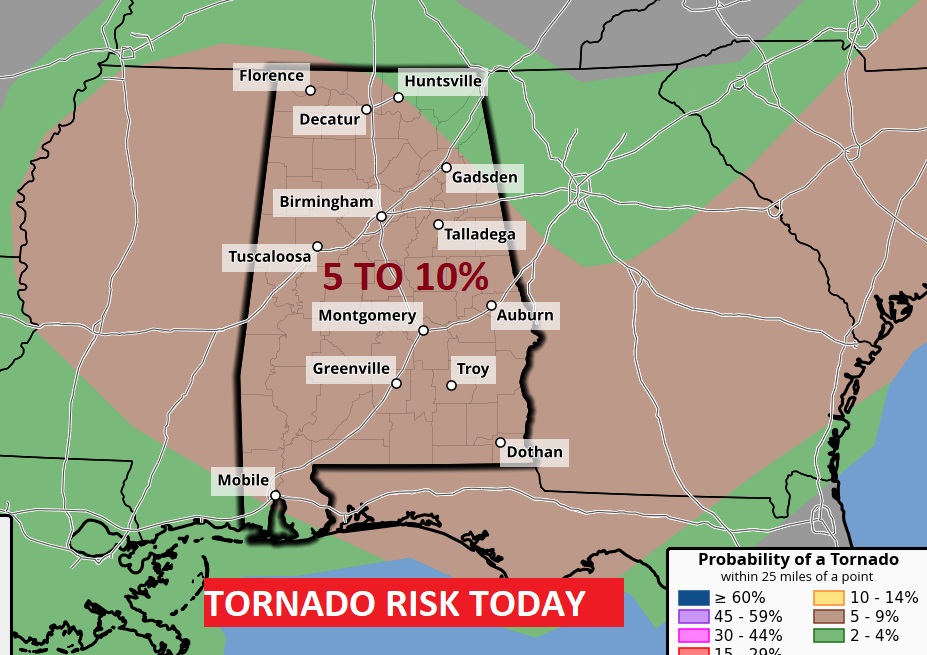
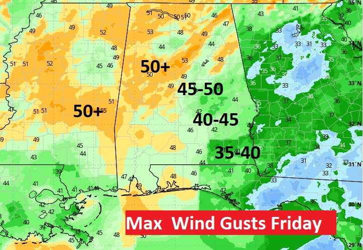
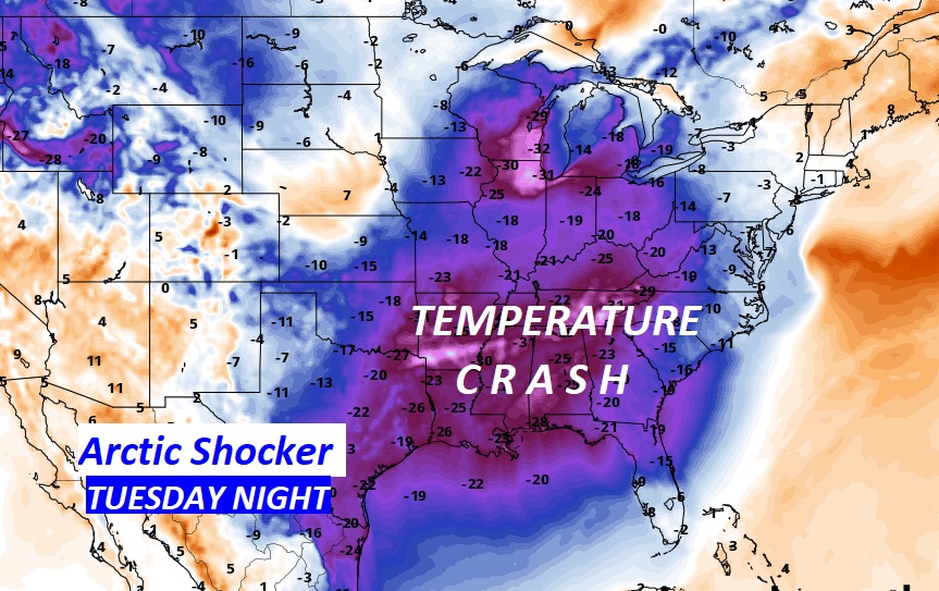
Good Morning! A potent storm system and cold front will cross the state today, brining yet another severe weather threat. For many of us, the main threat window begins late morning and continues through mid-afternoon. In southeast Alabama, the threat will start to come to an end around 4. Although damaging wind gusts will be the main threat, tornadoes are certainly possible. The BEST news is, the threat level has been reduced, from the Storm Prediction Center. The Enhanced tornado risk has been removed. Still though, discrete super cells out ahead of the main line of storms could start to rotate and produce tornadoes. The risk is still 5 to 10% of a tornado within 25 miles of any point. Our weather app will keep you on top of the action. Make sure your weather radio is in the alert position. You need at least 2 reliable ways of getting notification of a warning. NEVER depend on tornado sirens. Also, a Wind advisory is in effect today for 40-45 mph non-thunderstorm wind gusts. Then, are you ready for an Arctic Shocker? We have some very cold arctic air in our future. The main Arctic Temperature Crash arrives Tuesday. It’ll be the coldest air since Christmas Week 2022. Wait till you see the numbers below. Here’s my brief forecast discussion.
TODAY: Windy with showers and storms. Some storms will be Severe with damaging wind gusts the main threat. Tornadoes are certainly possible. High near 70. Wind advisory in effect. Non-thunderstorm winds could gust to 40-45 mph. The storm threat for many of us will be gone by mid afternoon as the storms shift into SE Alabama. Breezy and colder tonight. Low 31.
SEVERE WEATER RISK: The Level 3 Enhanced risk may be gone, but we all of us are in a Level 2 out of 5 Severe Risk today. A tornado watch is certainly likely. Although damaging wind gusts will be the main threat, tornadoes are certainly possible. The BEST news is, the threat level has been reduced, from the Storm Prediction Center. The Enhanced tornado risk has been removed. Still though, discrete super cells out ahead of the main line of storms could start to rotate and produce tornadoes.
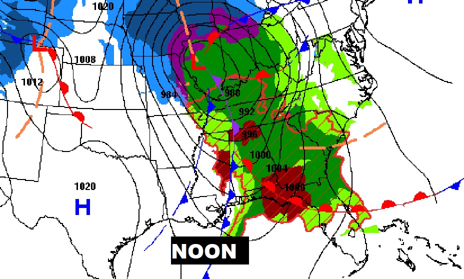
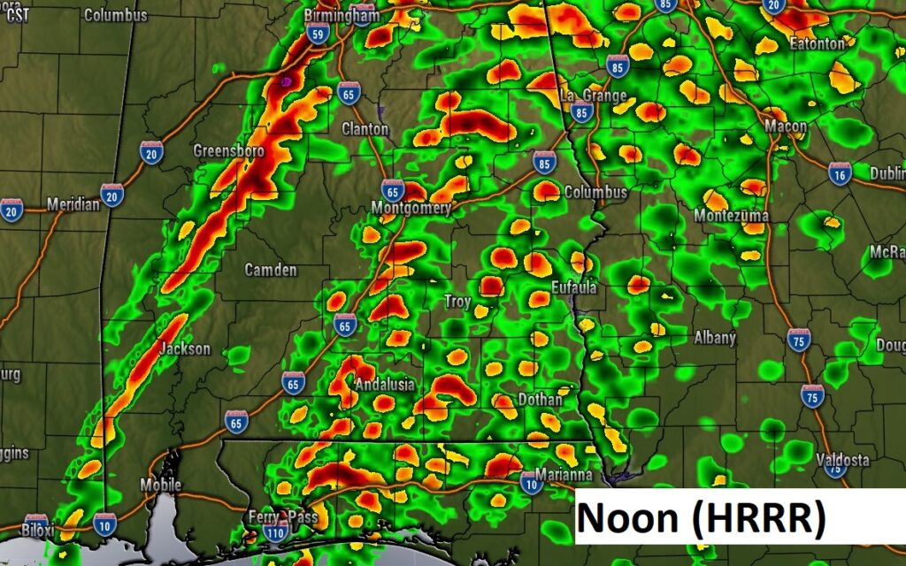
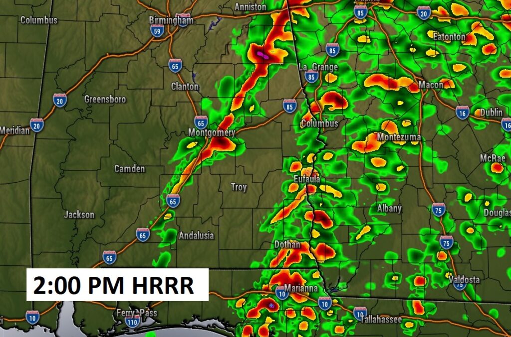
Future radar tells an interesting story. Notice at Noon, the main line of storms, ahead of the front, is in west Alabama. But, in central and east Alabama notice those individual cells, all by themselves. Some of those cells could start to rotate and drop tornadoes. By 2:00 PM, the HRRR model shows the main line along the I-65 corridor. After that the action will shift into SE Alabama.
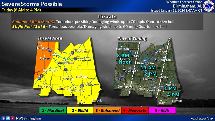
This updated timeline map from NWS Birmingham is helpful.
WIND ADVISORY: Today, non-thunderstorm winds could gust to 4o to 45 mph.
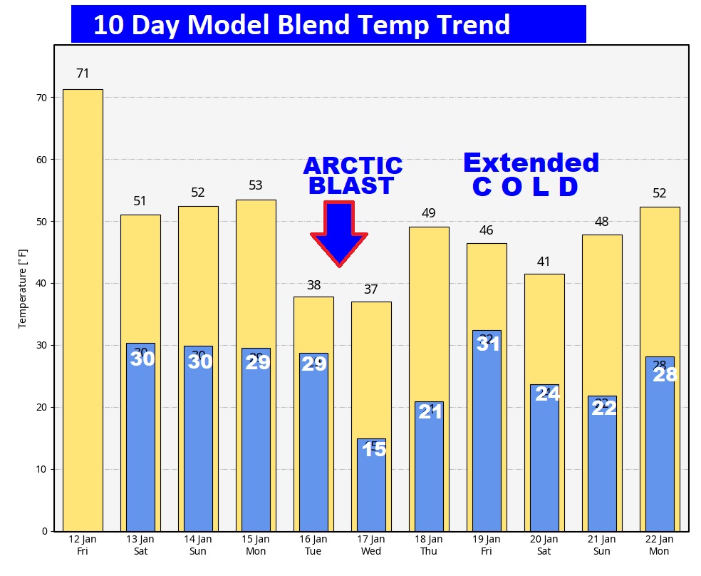
NEXT FEW DAYS: Behind the front. The weekend will be quite chilly. Then, get ready for the start of an arctic invasion starting over the weekend. Then, get ready for a Temperature Crash early to middle of next week. We have some very cold arctic air in our future. The main Arctic Temperature Crash arrives Tuesday. The numbers look pretty crazy. It’ll be the coldest air since Christmas Week 2022.
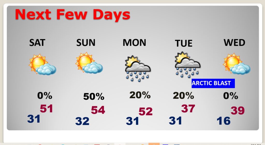
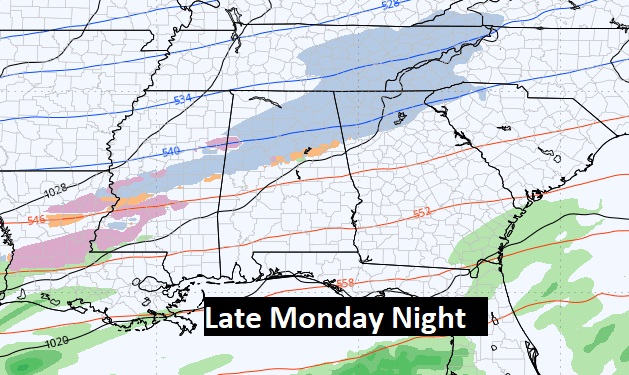
I hesitate to even mention this because it is so minor. But, yes there is a small chance of precipitation in the forecast as the Arctic Cold Front gets closer..mainly from late Monday (MLK Day) into early Tuesday. Could some of the precip. Be in a frozen form late Monday night? Extremely light, if it happens. Do we care? NO. Not a big deal, and we’re a few days away from it.
Ironically, TODAY is the one year anniversary of TWO Big Tornadoes last year. Downtown Selma. Plus, the Autauga county tornado which killed seven and injured many. I will be in Selma tomorrow, along with Shane Butler, James Spann and many dignities at this event in Selma.
This morning everything is normal including Live on the radio 6 to 9AM on NewsTalk 93.1 WACV. There will be another Blog update in the morning.
–Rich